Großkadolz geodata
Großkadolz (Lower Austria) is a populated place; located in Austria in Europe/Vienna (GMT+2) time zone. With population of 565 people, there are 2267 cities with bigger population in this country. Compared to other cities in Austria, 98.4% of cities are located further ↓South; 85.8% of cities are located further ←West and 93.3% of cities have higher elevation than Großkadolz. Note1
Administrative division(s):
- Level 1: Lower Austria
- Level 2: Politischer Bezirk Hollabrunn
- Level 3: Seefeld-Kadolz


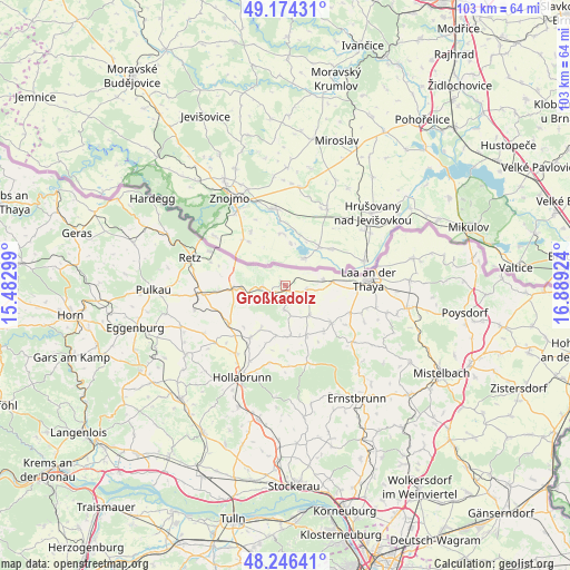
Großkadolz GPS coordinates[2]
48° 42' 45" North, 16° 11' 9.996" East
| Map corner | latitude | longitude |
|---|---|---|
| Upper-left | 49.17431°, | 15.48299° |
| Center: | 48.7125°, | 16.18611° |
| Lower-right: | 48.24641°, | 16.88924° |
| Map W x H: | 103.2×103.2 km | = 64.1×64.1mi |
| max Lat: | 48.98333° ⇑1.6% North |
| Großkadolz: | 48.7125° |
| min Lat: | ⇓98.4% South 46.48841° |
| min Long | Großkadolz | max Long |
| 9.57802° | 16.18611° | 17.1° |
| W 85.8%⇐ | ⇒14.2% E |
Elevation
Elevation of Großkadolz is 191 m = 627 ft, and this is 314.5 m = 1032 ft below average elevation for this country.
| Max E: |
2140 m = 7021 ft | 93.3% |
| Avg. | 505.5 m = 1658 ft | |
| Großkadolz | 191 m = 627 ft | |
Min E: |
118 m = 387 ft | 6.7% |
See also: Austria elevation on elevation.city.
Geographical zone
Großkadolz is located in North temperate zone (between Tropic of Cancer and the Arctic Circle). Distance of this North polar circle is 1984.9 km =1233.4 mi to North.| Distance of | km | miles | from Großkadolz |
|---|---|---|---|
| North Pole | 4590.7 | 2852.5 | to North |
| Arctic Circle | 1984.9 | 1233.4 | to North |
| Tropic Cancer | 2810.4 | 1746.3 | to South |
| Equator | 5416.3 | 3365.5 | to South |


Nearby cities:
15 places around Großkadolz: (largest is in red/bold)
• Alberndorf
6.5 km =4 mi,  257°
257°
• Großharras
6.9 km =4.3 mi,  141°
141°
• Guntersdorf
12.2 km =7.6 mi,  235°
235°
• Hadres
4.1 km =2.5 mi,  265°
265°
• Hanfthal
13.3 km =8.3 mi,  95°
95°
• Haugsdorf
8.1 km =5 mi, 266°
• Laa an der Thaya
14.5 km =9 mi,  88°
88°
• Mailberg
4.3 km =2.7 mi,  184°
184°
• Obritz
3 km =1.9 mi, 242°
• Pernersdorf
12.5 km =7.8 mi, 263°
• Stronsdorf
10.7 km =6.6 mi,  129°
129°
• Unterretzbach
14.9 km =9.3 mi,  293°
293°
• Unterstinkenbrunn
12.8 km =8 mi,  112°
112°
• Wullersdorf
11.3 km =7 mi,  213°
213°
• Wulzeshofen
8.4 km =5.2 mi, 86°
Sources, notices
• [Note1] Compared only with cities in Austria existing in our database
• [Src1] Map data: © OpenStreetMap contributors (CC-BY-SA)
• [Src2] Other city data from geonames.org with taken over terms of usage.
• [Src3] Geographical zone / Annual Mean Temperature by Robert A. Rohde @ Wikipedia
