Fürnitz geodata
Fürnitz (Carinthia) is a populated place; located in Austria in Europe/Vienna (GMT+2) time zone. With population of 1,520 people, there are 829 cities with bigger population in this country. Compared to other cities in Austria, 99.3% of cities are located further ↑North; 68.7% of cities are located further →East and 58.2% of cities have lower elevation than Fürnitz. Note1
Administrative division(s):
- Level 1: Carinthia
- Level 2: Politischer Bezirk Villach Land
- Level 3: Finkenstein am Faaker See


Fürnitz GPS coordinates[2]
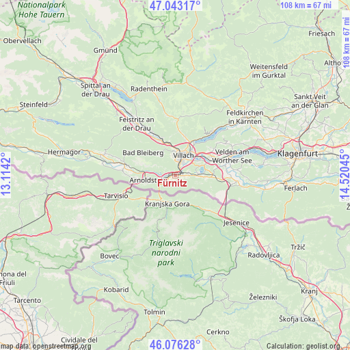
46° 33' 42.768" North, 13° 49' 2.352" East
| Map corner | latitude | longitude |
|---|---|---|
| Upper-left | 47.04317°, | 13.1142° |
| Center: | 46.56188°, | 13.81732° |
| Lower-right: | 46.07628°, | 14.52045° |
| Map W x H: | 107.5×107.5 km | = 66.8×66.8mi |
| max Lat: | 48.98333° ⇑99.3% North |
| Fürnitz: | 46.56188° |
| min Lat: | ⇓0.7% South 46.48841° |
| min Long | Fürnitz | max Long |
| 9.57802° | 13.81732° | 17.1° |
| W 31.3%⇐ | ⇒68.7% E |
Elevation
Elevation of Fürnitz is 507 m = 1663 ft, and this is 1.5 m = 5 ft above average elevation for this country.
| Max E: |
2140 m = 7021 ft | 41.8% |
| Fürnitz | 507 m 1663 ft | |
| Avg. | 505.5 m = 1658 ft | |
Min E: |
118 m = 387 ft | 58.2% |
See also: Austria elevation on elevation.city.
Geographical zone
Fürnitz is located in North temperate zone (between Tropic of Cancer and the Arctic Circle). Distance of this North polar circle is 2224 km =1381.9 mi to North.| Distance of | km | miles | from Fürnitz |
|---|---|---|---|
| North Pole | 4829.9 | 3001.2 | to North |
| Arctic Circle | 2224 | 1381.9 | to North |
| Tropic Cancer | 2571.3 | 1597.7 | to South |
| Equator | 5177.2 | 3217 | to South |


Nearby cities:
15 places around Fürnitz: (largest is in red/bold)
• Auen
4.7 km =2.9 mi,  25°
25°
• Finkenstein
4.1 km =2.5 mi,  90°
90°
• Goritschach
5.6 km =3.5 mi,  353°
353°
• Illitsch
4.6 km =2.9 mi,  124°
124°
• Maria Gail
5.9 km =3.7 mi,  55°
55°
• Neufellach
6.7 km =4.2 mi,  358°
358°
• Pöckau
5.8 km =3.6 mi,  256°
256°
• Riegersdorf
3.1 km =1.9 mi,  244°
244°
• Sankt Martin
6.2 km =3.9 mi,  8°
8°
• St. Agathen und Perau
5.8 km =3.6 mi, 31°
• Untere Fellach
7.1 km =4.4 mi, 5°
• Villach
6.1 km =3.8 mi, 28°
• Villach-Innere Stadt
6.1 km =3.8 mi,  21°
21°
• Völkendorf
5.2 km =3.2 mi, 11°
• Warmbad-Judendorf
4.4 km =2.7 mi, 5°
Sources, notices
• [Note1] Compared only with cities in Austria existing in our database
• [Src1] Map data: © OpenStreetMap contributors (CC-BY-SA)
• [Src2] Other city data from geonames.org with taken over terms of usage.
• [Src3] Geographical zone / Annual Mean Temperature by Robert A. Rohde @ Wikipedia
