Ebenfurth geodata
Ebenfurth (Lower Austria) is a seat of a third-order administrative division; located in Austria in Europe/Vienna (GMT+2) time zone. With population of 2,564 people, there are 464 cities with bigger population in this country. Compared to other cities in Austria, 60.1% of cities are located further ↓South; 90.3% of cities are located further ←West and 88.2% of cities have higher elevation than Ebenfurth. Note1
Administrative division(s):
- Level 1: Lower Austria
- Level 2: Politischer Bezirk Wiener Neustadt
- Level 3: Ebenfurth


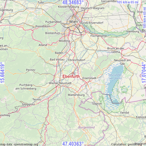
Ebenfurth GPS coordinates[2]
47° 52' 38.568" North, 16° 22' 2.316" East
| Map corner | latitude | longitude |
|---|---|---|
| Upper-left | 48.34683°, | 15.66419° |
| Center: | 47.87738°, | 16.36731° |
| Lower-right: | 47.40363°, | 17.07044° |
| Map W x H: | 104.9×104.9 km | = 65.2×65.2mi |
| max Lat: | 48.98333° ⇑39.9% North |
| Ebenfurth: | 47.87738° |
| min Lat: | ⇓60.1% South 46.48841° |
| min Long | Ebenfurth | max Long |
| 9.57802° | 16.36731° | 17.1° |
| W 90.3%⇐ | ⇒9.7% E |
Elevation
Elevation of Ebenfurth is 228 m = 748 ft, and this is 277.5 m = 910 ft below average elevation for this country.
| Max E: |
2140 m = 7021 ft | 88.2% |
| Avg. | 505.5 m = 1658 ft | |
| Ebenfurth | 228 m = 748 ft | |
Min E: |
118 m = 387 ft | 11.8% |
See also: Austria elevation on elevation.city.
Geographical zone
Ebenfurth is located in North temperate zone (between Tropic of Cancer and the Arctic Circle). Distance of this North polar circle is 2077.7 km =1291 mi to North.| Distance of | km | miles | from Ebenfurth |
|---|---|---|---|
| North Pole | 4683.6 | 2910.3 | to North |
| Arctic Circle | 2077.7 | 1291 | to North |
| Tropic Cancer | 2717.5 | 1688.6 | to South |
| Equator | 5323.5 | 3307.9 | to South |


Nearby cities:
15 places around Ebenfurth: (largest is in red/bold)
• Eggendorf
4 km =2.5 mi,  237°
237°
• Haschendorf
2.2 km =1.4 mi,  301°
301°
• Hornstein
5.8 km =3.6 mi,  86°
86°
• Landegg
3.5 km =2.2 mi,  44°
44°
• Lichtenwörth
7.5 km =4.7 mi,  222°
222°
• Neufeld an der Leitha
1.6 km =1 mi,  147°
147°
• Pottendorf
2.8 km =1.7 mi,  25°
25°
• Pöttsching
8.1 km =5 mi,  178°
178°
• Siegersdorf
2.8 km =1.7 mi,  332°
332°
• Steinbrunn
6.1 km =3.8 mi,  143°
143°
• Wampersdorf
5.7 km =3.5 mi, 40°
• Wimpassing an der Leitha
6.6 km =4.1 mi,  48°
48°
• Zillingdorf
4 km =2.5 mi, 219°
• Zillingdorf-Bergwerk
3.9 km =2.4 mi,  164°
164°
• Zillingtal
7.7 km =4.8 mi, 155°
Sources, notices
• [Note1] Compared only with cities in Austria existing in our database
• [Src1] Map data: © OpenStreetMap contributors (CC-BY-SA)
• [Src2] Other city data from geonames.org with taken over terms of usage.
• [Src3] Geographical zone / Annual Mean Temperature by Robert A. Rohde @ Wikipedia
