Pottendorf geodata
Pottendorf (Lower Austria) is a seat of a third-order administrative division; located in Austria in Europe/Vienna (GMT+2) time zone. With population of 4,508 people, there are 220 cities with bigger population in this country. Compared to other cities in Austria, 61% of cities are located further ↓South; 90.8% of cities are located further ←West and 89.1% of cities have higher elevation than Pottendorf. Note1
Administrative division(s):
- Level 1: Lower Austria
- Level 2: Politischer Bezirk Baden
- Level 3: Pottendorf


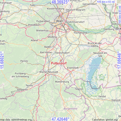
Pottendorf GPS coordinates[2]
47° 54' 0" North, 16° 22' 59.988" East
| Map corner | latitude | longitude |
|---|---|---|
| Upper-left | 48.36925°, | 15.68021° |
| Center: | 47.9°, | 16.38333° |
| Lower-right: | 47.42646°, | 17.08646° |
| Map W x H: | 104.8×104.8 km | = 65.1×65.1mi |
| max Lat: | 48.98333° ⇑39% North |
| Pottendorf: | 47.9° |
| min Lat: | ⇓61% South 46.48841° |
| min Long | Pottendorf | max Long |
| 9.57802° | 16.38333° | 17.1° |
| W 90.8%⇐ | ⇒9.2% E |
Elevation
Elevation of Pottendorf is 219 m = 719 ft, and this is 286.5 m = 940 ft below average elevation for this country.
| Max E: |
2140 m = 7021 ft | 89.1% |
| Avg. | 505.5 m = 1658 ft | |
| Pottendorf | 219 m = 719 ft | |
Min E: |
118 m = 387 ft | 10.9% |
See also: Austria elevation on elevation.city.
Geographical zone
Pottendorf is located in North temperate zone (between Tropic of Cancer and the Arctic Circle). Distance of this North polar circle is 2075.2 km =1289.5 mi to North.| Distance of | km | miles | from Pottendorf |
|---|---|---|---|
| North Pole | 4681.1 | 2908.7 | to North |
| Arctic Circle | 2075.2 | 1289.5 | to North |
| Tropic Cancer | 2720.1 | 1690.2 | to South |
| Equator | 5326 | 3309.4 | to South |


Nearby cities:
15 places around Pottendorf: (largest is in red/bold)
• Ebenfurth
2.8 km =1.7 mi,  205°
205°
• Ebreichsdorf
6.5 km =4 mi,  15°
15°
• Eggendorf
6.5 km =4 mi,  224°
224°
• Haschendorf
3.3 km =2.1 mi,  246°
246°
• Hornstein
5 km =3.1 mi,  115°
115°
• Landegg
1.2 km =0.7 mi,  90°
90°
• Neufeld an der Leitha
3.8 km =2.4 mi,  185°
185°
• Siegersdorf
2.5 km =1.6 mi,  270°
270°
• Steinbrunn
7.8 km =4.8 mi,  161°
161°
• Unterwaltersdorf
6.1 km =3.8 mi, 24°
• Wampersdorf
3.1 km =1.9 mi,  53°
53°
• Weigelsdorf
5.7 km =3.5 mi,  12°
12°
• Wimpassing an der Leitha
4.2 km =2.6 mi,  63°
63°
• Zillingdorf
6.7 km =4.2 mi, 213°
• Zillingdorf-Bergwerk
6.3 km =3.9 mi,  181°
181°
Sources, notices
• [Note1] Compared only with cities in Austria existing in our database
• [Src1] Map data: © OpenStreetMap contributors (CC-BY-SA)
• [Src2] Other city data from geonames.org with taken over terms of usage.
• [Src3] Geographical zone / Annual Mean Temperature by Robert A. Rohde @ Wikipedia
