Mörtschach geodata
Mörtschach (Carinthia) is a seat of a third-order administrative division; located in Austria in Europe/Vienna (GMT+2) time zone. With population of 249 people, there are 2811 cities with bigger population in this country. Compared to other cities in Austria, 87.4% of cities are located further ↑North; 83.7% of cities are located further →East and 97.4% of cities have lower elevation than Mörtschach. Note1
Administrative division(s):
- Level 1: Carinthia
- Level 2: Politischer Bezirk Spittal an der Drau
- Level 3: Mörtschach


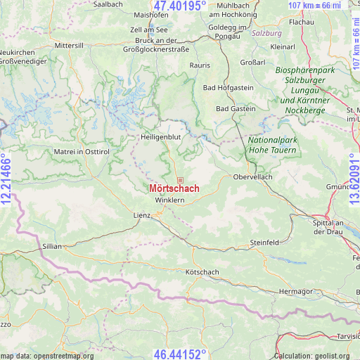
Mörtschach GPS coordinates[2]
46° 55' 26.004" North, 12° 55' 4.008" East
| Map corner | latitude | longitude |
|---|---|---|
| Upper-left | 47.40195°, | 12.21466° |
| Center: | 46.92389°, | 12.91778° |
| Lower-right: | 46.44152°, | 13.62091° |
| Map W x H: | 106.8×106.8 km | = 66.4×66.4mi |
| max Lat: | 48.98333° ⇑87.4% North |
| Mörtschach: | 46.92389° |
| min Lat: | ⇓12.6% South 46.48841° |
| min Long | Mörtschach | max Long |
| 9.57802° | 12.91778° | 17.1° |
| W 16.3%⇐ | ⇒83.7% E |
Elevation
Elevation of Mörtschach is 1150 m = 3773 ft, and this is 644.5 m = 2115 ft above average elevation for this country.
| Max E: |
2140 m = 7021 ft | 2.6% |
| Mörtschach | 1150 m 3773 ft | |
| Avg. | 505.5 m = 1658 ft | |
Min E: |
118 m = 387 ft | 97.4% |
See also: Austria elevation on elevation.city.
Geographical zone
Mörtschach is located in North temperate zone (between Tropic of Cancer and the Arctic Circle). Distance of this North polar circle is 2183.7 km =1356.9 mi to North.| Distance of | km | miles | from Mörtschach |
|---|---|---|---|
| North Pole | 4789.6 | 2976.1 | to North |
| Arctic Circle | 2183.7 | 1356.9 | to North |
| Tropic Cancer | 2611.5 | 1622.7 | to South |
| Equator | 5217.4 | 3241.9 | to South |


Nearby cities:
15 places around Mörtschach: (largest is in red/bold)
• Debant
12.7 km =7.9 mi,  217°
217°
• Dölsach
12 km =7.5 mi,  207°
207°
• Flattach
16.5 km =10.3 mi,  84°
84°
• Großkirchheim
5.7 km =3.5 mi,  342°
342°
• Heiligenblut
14.1 km =8.8 mi, 336°
• Lavant
15.2 km =9.4 mi,  203°
203°
• Lienz
15.5 km =9.6 mi,  226°
226°
• Nikolsdorf
15.4 km =9.6 mi,  181°
181°
• Nußdorf
13.5 km =8.4 mi, 221°
• Oberlienz
16.5 km =10.3 mi,  238°
238°
• Rangersdorf
7.5 km =4.7 mi,  161°
161°
• Stall
9.8 km =6.1 mi,  112°
112°
• Thurn
14 km =8.7 mi, 234°
• Tristach
15.4 km =9.6 mi, 219°
• Winklern
6.5 km =4 mi, 210°
Sources, notices
• [Note1] Compared only with cities in Austria existing in our database
• [Src1] Map data: © OpenStreetMap contributors (CC-BY-SA)
• [Src2] Other city data from geonames.org with taken over terms of usage.
• [Src3] Geographical zone / Annual Mean Temperature by Robert A. Rohde @ Wikipedia
