Baierdorf-Umgebung geodata
Baierdorf-Umgebung (Styria) is a seat of a third-order administrative division; located in Austria in Europe/Vienna (GMT+2) time zone. With population of 903 people, there are 1422 cities with bigger population in this country. Compared to other cities in Austria, 66.5% of cities are located further ↑North; 72.4% of cities are located further ←West and 77% of cities have lower elevation than Baierdorf-Umgebung. Note1


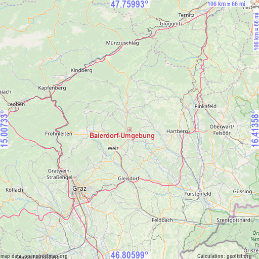
Baierdorf-Umgebung GPS coordinates[2]
47° 17' 6.396" North, 15° 42' 37.62" East
| Map corner | latitude | longitude |
|---|---|---|
| Upper-left | 47.75993°, | 15.00733° |
| Center: | 47.28511°, | 15.71045° |
| Lower-right: | 46.80599°, | 16.41358° |
| Map W x H: | 106.1×106.1 km | = 65.9×65.9mi |
| max Lat: | 48.98333° ⇑66.5% North |
| Baierdorf-Umgebung: | 47.28511° |
| min Lat: | ⇓33.5% South 46.48841° |
| min Long | Baierdorf-Umgeb | max Long |
| 9.57802° | 15.71045° | 17.1° |
| W 72.4%⇐ | ⇒27.6% E |
Elevation
Elevation of Baierdorf-Umgebung is 675 m = 2215 ft, and this is 169.5 m = 556 ft above average elevation for this country.
| Max E: |
2140 m = 7021 ft | 23% |
| Baierdorf-Umgebung | 675 m 2215 ft | |
| Avg. | 505.5 m = 1658 ft | |
Min E: |
118 m = 387 ft | 77% |
See also: Austria elevation on elevation.city.
Geographical zone
Baierdorf-Umgebung is located in North temperate zone (between Tropic of Cancer and the Arctic Circle). Distance of this North polar circle is 2143.6 km =1332 mi to North.| Distance of | km | miles | from Baierdorf-Umgebung |
|---|---|---|---|
| North Pole | 4749.5 | 2951.2 | to North |
| Arctic Circle | 2143.6 | 1332 | to North |
| Tropic Cancer | 2651.7 | 1647.7 | to South |
| Equator | 5257.6 | 3266.9 | to South |


Nearby cities:
15 places around Baierdorf-Umgebung: (largest is in red/bold)
• Anger
1.9 km =1.2 mi,  229°
229°
• Birkfeld
7.5 km =4.7 mi,  344°
344°
• Etzersdorf
9.7 km =6 mi,  192°
192°
• Floing
3.6 km =2.2 mi,  131°
131°
• Gschaid bei Birkfeld
7.5 km =4.7 mi,  354°
354°
• Miesenbach bei Birkfeld
10 km =6.2 mi,  25°
25°
• Naas
9.5 km =5.9 mi,  246°
246°
• Oberfeistritz
4 km =2.5 mi, 191°
• Obersaifen
6.5 km =4 mi,  57°
57°
• Puch bei Weiz
7.6 km =4.7 mi,  176°
176°
• Pöllau
9.4 km =5.8 mi,  79°
79°
• Sankt Kathrein am Offenegg
9.7 km =6 mi,  279°
279°
• Sankt Kathrein am Offenegg I Viertel
9.7 km =6 mi, 278°
• Stubenberg
8.1 km =5 mi,  123°
123°
• Zeil
6.7 km =4.2 mi, 125°
Sources, notices
• [Note1] Compared only with cities in Austria existing in our database
• [Src1] Map data: © OpenStreetMap contributors (CC-BY-SA)
• [Src2] Other city data from geonames.org with taken over terms of usage.
• [Src3] Geographical zone / Annual Mean Temperature by Robert A. Rohde @ Wikipedia
