Wundowie geodata
Wundowie (Western Australia) is a populated place; located in Australia in Australia/Perth (GMT+8) time zone. With population of 1,306 people, there are 3468 cities with bigger population in this country. Compared to other cities in Australia, 68.5% of cities are located further ↓South; 91.1% of cities are located further →East and 86.9% of cities have lower elevation than Wundowie. Note1


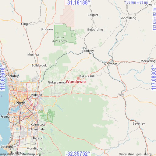
Wundowie GPS coordinates[2]
31° 45' 41.868" South, 116° 22' 47.64" East
| Map corner | latitude | longitude |
|---|---|---|
| Upper-left | -31.16188°, | 115.67678° |
| Center: | -31.76163°, | 116.3799° |
| Lower-right: | -32.35752°, | 117.08303° |
| Map W x H: | 132.9×132.9 km | = 82.6×82.6mi |
| max Lat: | -10.58257° ⇑31.5% North |
| Wundowie: | -31.76163° |
| min Lat: | ⇓68.5% South -43.31423° |
| min Long | Wundowie | max Long |
| 113.53327° | 116.3799° | 153.61246° |
| W 8.9%⇐ | ⇒91.1% E |
Elevation
Elevation of Wundowie is 285 m = 935 ft, and this is 163 m = 535 ft above average elevation for this country.
| Max E: |
1715 m = 5627 ft | 13.1% |
| Wundowie | 285 m 935 ft | |
| Avg. | 122 m = 400 ft | |
Min E: |
-2 m = -7 ft | 86.9% |
See also: Australia elevation on elevation.city.
Geographical zone
Wundowie is located in South temperate zone (between Tropic of Capricorn and the Antarctic Circle). Distance of this Southern Tropic circle is 925.6 km =575.1 mi to North.| Distance of | km | miles | from Wundowie |
|---|---|---|---|
| Equator | 3531.6 | 2194.4 | to North |
| Tropic Capricorn | 925.6 | 575.1 | to North |
| Antarctic Circle | 3869.6 | 2404.5 | to South |
| South Pole | 6475.5 | 4023.7 | to South |


Nearby cities:
15 places around Wundowie: (largest is in red/bold)
• Bakers Hill
7.6 km =4.7 mi,  77°
77°
• Brigadoon
29.1 km =18.1 mi,  267°
267°
• Chidlow
15 km =9.3 mi,  222°
222°
• Gidgegannup
18.2 km =11.3 mi, 272°
• Hovea
29.7 km =18.5 mi,  242°
242°
• Mahogany Creek
28 km =17.4 mi, 235°
• Morangup
13.3 km =8.3 mi,  320°
320°
• Mount Helena
20.5 km =12.7 mi,  231°
231°
• Mundaring
25.4 km =15.8 mi, 232°
• Parkerville
26.1 km =16.2 mi, 241°
• Sawyers Valley
23.1 km =14.4 mi, 227°
• Stoneville
23.6 km =14.7 mi, 236°
• Toodyay
25 km =15.5 mi,  19°
19°
• West Toodyay
25.6 km =15.9 mi,  7°
7°
• Wooroloo
7.9 km =4.9 mi, 233°
Sources, notices
• [Note1] Compared only with cities in Australia existing in our database
• [Src1] Map data: © OpenStreetMap contributors (CC-BY-SA)
• [Src2] Other city data from geonames.org with taken over terms of usage.
• [Src3] Geographical zone / Annual Mean Temperature by Robert A. Rohde @ Wikipedia
