West Toodyay geodata
West Toodyay (Western Australia) is a populated place; located in Australia in Australia/Perth (GMT+8) time zone. With population of 502 people, there are 4875 cities with bigger population in this country. Compared to other cities in Australia, 69.6% of cities are located further ↓South; 91% of cities are located further →East and 75.4% of cities have lower elevation than West Toodyay. Note1


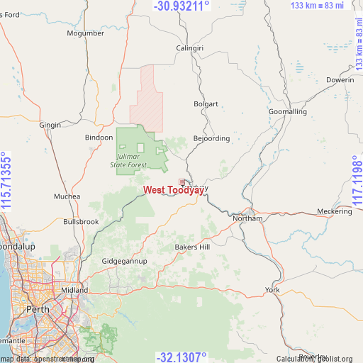
West Toodyay GPS coordinates[2]
31° 31' 59.988" South, 116° 25' 0.012" East
| Map corner | latitude | longitude |
|---|---|---|
| Upper-left | -30.93211°, | 115.71355° |
| Center: | -31.53333°, | 116.41667° |
| Lower-right: | -32.1307°, | 117.1198° |
| Map W x H: | 133.3×133.3 km | = 82.8×82.8mi |
| max Lat: | -10.58257° ⇑30.4% North |
| West Toodyay: | -31.53333° |
| min Lat: | ⇓69.6% South -43.31423° |
| min Long | West Toodyay | max Long |
| 113.53327° | 116.41667° | 153.61246° |
| W 9%⇐ | ⇒91% E |
Elevation
Elevation of West Toodyay is 135 m = 443 ft, and this is 13 m = 43 ft above average elevation for this country.
| Max E: |
1715 m = 5627 ft | 24.6% |
| West Toodyay | 135 m 443 ft | |
| Avg. | 122 m = 400 ft | |
Min E: |
-2 m = -7 ft | 75.4% |
See also: Australia elevation on elevation.city.
Geographical zone
West Toodyay is located in South temperate zone (between Tropic of Capricorn and the Antarctic Circle). Distance of this Southern Tropic circle is 900.3 km =559.4 mi to North.| Distance of | km | miles | from West Toodyay |
|---|---|---|---|
| Equator | 3506.2 | 2178.7 | to North |
| Tropic Capricorn | 900.3 | 559.4 | to North |
| Antarctic Circle | 3895 | 2420.2 | to South |
| South Pole | 6500.9 | 4039.5 | to South |


Nearby cities:
15 places around West Toodyay: (largest is in red/bold)
• Bakers Hill
24.1 km =15 mi,  170°
170°
• Bindoon
34.5 km =21.4 mi,  298°
298°
• Brigadoon
42 km =26.1 mi,  230°
230°
• Bullsbrook
42.3 km =26.3 mi,  249°
249°
• Chidlow
38.9 km =24.2 mi,  200°
200°
• Chittering
32.7 km =20.3 mi,  282°
282°
• Coondle
5.8 km =3.6 mi,  10°
10°
• Gidgegannup
32.8 km =20.4 mi,  221°
221°
• Lower Chittering
29 km =18 mi,  258°
258°
• Morangup
19.2 km =11.9 mi, 218°
• Northam
27.6 km =17.1 mi,  117°
117°
• Pearce
40.7 km =25.3 mi, 248°
• Toodyay
5.1 km =3.2 mi,  110°
110°
• Wooroloo
31.6 km =19.6 mi, 198°
• Wundowie
25.6 km =15.9 mi,  187°
187°
Sources, notices
• [Note1] Compared only with cities in Australia existing in our database
• [Src1] Map data: © OpenStreetMap contributors (CC-BY-SA)
• [Src2] Other city data from geonames.org with taken over terms of usage.
• [Src3] Geographical zone / Annual Mean Temperature by Robert A. Rohde @ Wikipedia
