Bakers Hill geodata
Bakers Hill (Western Australia) is a populated place; located in Australia in Australia/Perth (GMT+8) time zone. With population of 1,114 people, there are 3683 cities with bigger population in this country. Compared to other cities in Australia, 68.7% of cities are located further ↓South; 91% of cities are located further →East and 87.3% of cities have lower elevation than Bakers Hill. Note1


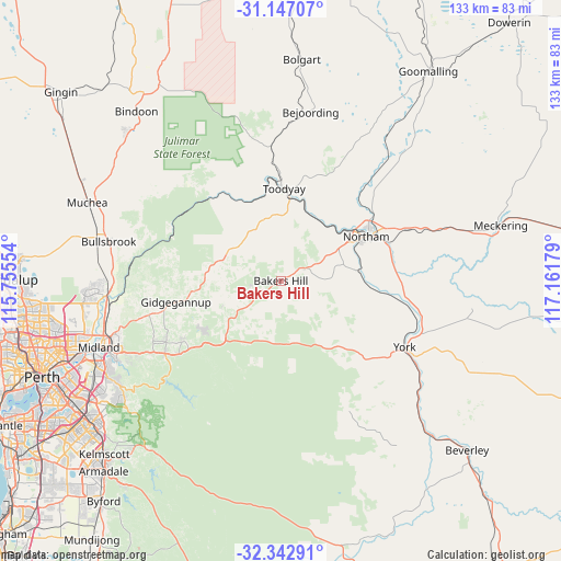
Bakers Hill GPS coordinates[2]
31° 44' 48.912" South, 116° 27' 31.176" East
| Map corner | latitude | longitude |
|---|---|---|
| Upper-left | -31.14707°, | 115.75554° |
| Center: | -31.74692°, | 116.45866° |
| Lower-right: | -32.34291°, | 117.16179° |
| Map W x H: | 133×133 km | = 82.6×82.6mi |
| max Lat: | -10.58257° ⇑31.3% North |
| Bakers Hill: | -31.74692° |
| min Lat: | ⇓68.7% South -43.31423° |
| min Long | Bakers Hill | max Long |
| 113.53327° | 116.45866° | 153.61246° |
| W 9%⇐ | ⇒91% E |
Elevation
Elevation of Bakers Hill is 296 m = 971 ft, and this is 174 m = 571 ft above average elevation for this country.
| Max E: |
1715 m = 5627 ft | 12.7% |
| Bakers Hill | 296 m 971 ft | |
| Avg. | 122 m = 400 ft | |
Min E: |
-2 m = -7 ft | 87.3% |
See also: Australia elevation on elevation.city.
Geographical zone
Bakers Hill is located in South temperate zone (between Tropic of Capricorn and the Antarctic Circle). Distance of this Southern Tropic circle is 924 km =574.1 mi to North.| Distance of | km | miles | from Bakers Hill |
|---|---|---|---|
| Equator | 3529.9 | 2193.4 | to North |
| Tropic Capricorn | 924 | 574.1 | to North |
| Antarctic Circle | 3871.2 | 2405.5 | to South |
| South Pole | 6477.1 | 4024.7 | to South |


Nearby cities:
15 places around Bakers Hill: (largest is in red/bold)
• Chidlow
21.7 km =13.5 mi,  234°
234°
• Coondle
29.6 km =18.4 mi,  354°
354°
• Gidgegannup
25.7 km =16 mi,  268°
268°
• Morangup
18.1 km =11.2 mi,  298°
298°
• Mount Helena
27.5 km =17.1 mi,  238°
238°
• Mundaring
32.5 km =20.2 mi, 237°
• Northam
23.1 km =14.4 mi,  61°
61°
• Parkerville
33.5 km =20.8 mi, 244°
• Sawyers Valley
29.9 km =18.6 mi, 234°
• Stoneville
30.9 km =19.2 mi, 241°
• Toodyay
21.9 km =13.6 mi,  2°
2°
• West Toodyay
24.1 km =15 mi, 350°
• Wooroloo
15.1 km =9.4 mi,  245°
245°
• Wundowie
7.6 km =4.7 mi,  257°
257°
• York
33.2 km =20.6 mi,  118°
118°
Sources, notices
• [Note1] Compared only with cities in Australia existing in our database
• [Src1] Map data: © OpenStreetMap contributors (CC-BY-SA)
• [Src2] Other city data from geonames.org with taken over terms of usage.
• [Src3] Geographical zone / Annual Mean Temperature by Robert A. Rohde @ Wikipedia
