Toodyay geodata
Toodyay (Western Australia) is a populated place; located in Australia in Australia/Perth (GMT+8) time zone. With population of 1,365 people, there are 3397 cities with bigger population in this country. Compared to other cities in Australia, 69.6% of cities are located further ↓South; 91% of cities are located further →East and 75.7% of cities have lower elevation than Toodyay. Note1


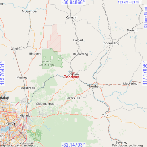
Toodyay GPS coordinates[2]
31° 32' 59.172" South, 116° 28' 2.748" East
| Map corner | latitude | longitude |
|---|---|---|
| Upper-left | -30.94866°, | 115.76431° |
| Center: | -31.54977°, | 116.46743° |
| Lower-right: | -32.14703°, | 117.17056° |
| Map W x H: | 133.2×133.2 km | = 82.8×82.8mi |
| max Lat: | -10.58257° ⇑30.4% North |
| Toodyay: | -31.54977° |
| min Lat: | ⇓69.6% South -43.31423° |
| min Long | Toodyay | max Long |
| 113.53327° | 116.46743° | 153.61246° |
| W 9%⇐ | ⇒91% E |
Elevation
Elevation of Toodyay is 137 m = 449 ft, and this is 15 m = 49 ft above average elevation for this country.
| Max E: |
1715 m = 5627 ft | 24.3% |
| Toodyay | 137 m 449 ft | |
| Avg. | 122 m = 400 ft | |
Min E: |
-2 m = -7 ft | 75.7% |
See also: Australia elevation on elevation.city.
Geographical zone
Toodyay is located in South temperate zone (between Tropic of Capricorn and the Antarctic Circle). Distance of this Southern Tropic circle is 902.1 km =560.5 mi to North.| Distance of | km | miles | from Toodyay |
|---|---|---|---|
| Equator | 3508 | 2179.8 | to North |
| Tropic Capricorn | 902.1 | 560.5 | to North |
| Antarctic Circle | 3893.2 | 2419.1 | to South |
| South Pole | 6499.1 | 4038.4 | to South |


Nearby cities:
15 places around Toodyay: (largest is in red/bold)
• Bakers Hill
21.9 km =13.6 mi,  182°
182°
• Bindoon
39.6 km =24.6 mi,  297°
297°
• Chidlow
39.2 km =24.4 mi,  208°
208°
• Chittering
37.8 km =23.5 mi,  283°
283°
• Coondle
8.4 km =5.2 mi,  333°
333°
• Gidgegannup
34.9 km =21.7 mi,  229°
229°
• Goomalling
43.8 km =27.2 mi,  50°
50°
• Lower Chittering
33.4 km =20.8 mi,  263°
263°
• Morangup
21.3 km =13.2 mi, 231°
• Mount Helena
43.7 km =27.2 mi, 213°
• Northam
22.5 km =14 mi,  119°
119°
• Pearce
44.6 km =27.7 mi,  253°
253°
• West Toodyay
5.1 km =3.2 mi,  290°
290°
• Wooroloo
31.8 km =19.8 mi, 207°
• Wundowie
25 km =15.5 mi,  199°
199°
Sources, notices
• [Note1] Compared only with cities in Australia existing in our database
• [Src1] Map data: © OpenStreetMap contributors (CC-BY-SA)
• [Src2] Other city data from geonames.org with taken over terms of usage.
• [Src3] Geographical zone / Annual Mean Temperature by Robert A. Rohde @ Wikipedia
