Wallaroo geodata
Wallaroo (South Australia) is a populated place; located in Australia in Australia/Adelaide (GMT+10.5) time zone. With population of 3,529 people, there are 1981 cities with bigger population in this country. Compared to other cities in Australia, 57.5% of cities are located further ↑North; 85.7% of cities are located further →East and 68.6% of cities have higher elevation than Wallaroo. Note1


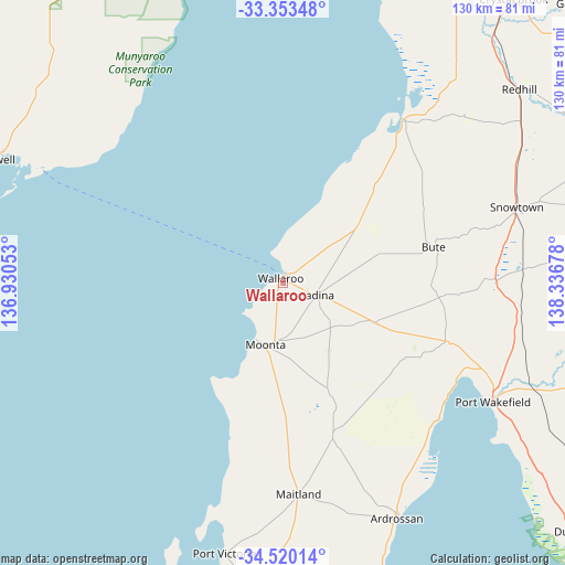
Wallaroo GPS coordinates[2]
33° 56' 19.716" South, 137° 38' 1.14" East
| Map corner | latitude | longitude |
|---|---|---|
| Upper-left | -33.35348°, | 136.93053° |
| Center: | -33.93881°, | 137.63365° |
| Lower-right: | -34.52014°, | 138.33678° |
| Map W x H: | 129.7×129.7 km | = 80.6×80.6mi |
| max Lat: | -10.58257° ⇑57.5% North |
| Wallaroo: | -33.93881° |
| min Lat: | ⇓42.5% South -43.31423° |
| min Long | Wallaroo | max Long |
| 113.53327° | 137.63365° | 153.61246° |
| W 14.3%⇐ | ⇒85.7% E |
Elevation
Elevation of Wallaroo is 24 m = 79 ft, and this is 98 m = 322 ft below average elevation for this country.
| Max E: |
1715 m = 5627 ft | 68.6% |
| Avg. | 122 m = 400 ft | |
| Wallaroo | 24 m = 79 ft | |
Min E: |
-2 m = -7 ft | 31.4% |
See also: Australia elevation on elevation.city.
Geographical zone
Wallaroo is located in South temperate zone (between Tropic of Capricorn and the Antarctic Circle). Distance of this Southern Tropic circle is 1167.7 km =725.6 mi to North.| Distance of | km | miles | from Wallaroo |
|---|---|---|---|
| Equator | 3773.6 | 2344.8 | to North |
| Tropic Capricorn | 1167.7 | 725.6 | to North |
| Antarctic Circle | 3627.5 | 2254 | to South |
| South Pole | 6233.4 | 3873.3 | to South |


Nearby cities:
15 places around Wallaroo: (largest is in red/bold)
• Ardrossan
59.8 km =37.2 mi,  153°
153°
• Balaklava
75.3 km =46.8 mi,  107°
107°
• Cowell
71.7 km =44.6 mi,  293°
293°
• Crystal Brook
84.2 km =52.3 mi,  39°
39°
• Kadina
8.2 km =5.1 mi, 110°
• Maitland
48.5 km =30.1 mi,  175°
175°
• Moonta
14.9 km =9.3 mi,  195°
195°
• Moonta Bay
13.8 km =8.6 mi,  206°
206°
• North Moonta
13.2 km =8.2 mi, 196°
• Port Broughton
46.8 km =29.1 mi, 36°
• Port Hughes
17.8 km =11.1 mi, 205°
• Port Pirie South
89.6 km =55.7 mi,  23°
23°
• Port Wakefield
54.5 km =33.9 mi,  120°
120°
• Risdon Park
89 km =55.3 mi, 22°
• Risdon Park South
87.6 km =54.4 mi, 22°
Sources, notices
• [Note1] Compared only with cities in Australia existing in our database
• [Src1] Map data: © OpenStreetMap contributors (CC-BY-SA)
• [Src2] Other city data from geonames.org with taken over terms of usage.
• [Src3] Geographical zone / Annual Mean Temperature by Robert A. Rohde @ Wikipedia
