Maitland geodata
Maitland (South Australia) is a populated place; located in Australia in Australia/Adelaide (GMT+10.5) time zone. With population of 1,222 people, there are 3558 cities with bigger population in this country. Compared to other cities in Australia, 62.2% of cities are located further ↑North; 85.6% of cities are located further →East and 80.9% of cities have lower elevation than Maitland. Note1


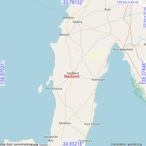
Maitland GPS coordinates[2]
34° 22' 25.896" South, 137° 40' 23.988" East
| Map corner | latitude | longitude |
|---|---|---|
| Upper-left | -33.79152°, | 136.97021° |
| Center: | -34.37386°, | 137.67333° |
| Lower-right: | -34.95218°, | 138.37646° |
| Map W x H: | 129.1×129.1 km | = 80.2×80.2mi |
| max Lat: | -10.58257° ⇑62.2% North |
| Maitland: | -34.37386° |
| min Lat: | ⇓37.8% South -43.31423° |
| min Long | Maitland | max Long |
| 113.53327° | 137.67333° | 153.61246° |
| W 14.4%⇐ | ⇒85.6% E |
Elevation
Elevation of Maitland is 192 m = 630 ft, and this is 70 m = 230 ft above average elevation for this country.
| Max E: |
1715 m = 5627 ft | 19.1% |
| Maitland | 192 m 630 ft | |
| Avg. | 122 m = 400 ft | |
Min E: |
-2 m = -7 ft | 80.9% |
See also: Australia elevation on elevation.city.
Geographical zone
Maitland is located in South temperate zone (between Tropic of Capricorn and the Antarctic Circle). Distance of this Southern Tropic circle is 1216.1 km =755.6 mi to North.| Distance of | km | miles | from Maitland |
|---|---|---|---|
| Equator | 3822 | 2374.9 | to North |
| Tropic Capricorn | 1216.1 | 755.6 | to North |
| Antarctic Circle | 3579.2 | 2224 | to South |
| South Pole | 6185 | 3843.2 | to South |


Nearby cities:
15 places around Maitland: (largest is in red/bold)
• Ardrossan
23.2 km =14.4 mi,  103°
103°
• Balaklava
72.4 km =45 mi,  69°
69°
• Honiton
82.6 km =51.3 mi,  181°
181°
• Kadina
45.6 km =28.3 mi,  4°
4°
• Mallala
77.1 km =47.9 mi, 95°
• Minlaton
44.7 km =27.8 mi,  189°
189°
• Moonta
34.8 km =21.6 mi,  347°
347°
• Moonta Bay
37.3 km =23.2 mi,  344°
344°
• North Moonta
36.4 km =22.6 mi, 348°
• Port Hughes
34.2 km =21.3 mi, 340°
• Port Wakefield
48.2 km =30 mi,  64°
64°
• Stansbury
60.8 km =37.8 mi,  169°
169°
• Two Wells
80.8 km =50.2 mi,  107°
107°
• Wallaroo
48.5 km =30.1 mi,  355°
355°
• Yorketown
71.9 km =44.7 mi, 184°
Sources, notices
• [Note1] Compared only with cities in Australia existing in our database
• [Src1] Map data: © OpenStreetMap contributors (CC-BY-SA)
• [Src2] Other city data from geonames.org with taken over terms of usage.
• [Src3] Geographical zone / Annual Mean Temperature by Robert A. Rohde @ Wikipedia
