Cowell geodata
Cowell (South Australia) is a populated place; located in Australia in Australia/Adelaide (GMT+10.5) time zone. With population of 1,250 people, there are 3519 cities with bigger population in this country. Compared to other cities in Australia, 51.6% of cities are located further ↓South; 85.9% of cities are located further →East and 90.1% of cities have higher elevation than Cowell. Note1


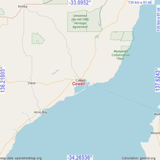
Cowell GPS coordinates[2]
33° 40' 56.172" South, 136° 55' 16.212" East
| Map corner | latitude | longitude |
|---|---|---|
| Upper-left | -33.0952°, | 136.21805° |
| Center: | -33.68227°, | 136.92117° |
| Lower-right: | -34.26536°, | 137.6243° |
| Map W x H: | 130.1×130.1 km | = 80.8×80.8mi |
| max Lat: | -10.58257° ⇑48.4% North |
| Cowell: | -33.68227° |
| min Lat: | ⇓51.6% South -43.31423° |
| min Long | Cowell | max Long |
| 113.53327° | 136.92117° | 153.61246° |
| W 14.1%⇐ | ⇒85.9% E |
Elevation
Elevation of Cowell is 9 m = 30 ft, and this is 113 m = 371 ft below average elevation for this country.
| Max E: |
1715 m = 5627 ft | 90.1% |
| Avg. | 122 m = 400 ft | |
| Cowell | 9 m = 30 ft | |
Min E: |
-2 m = -7 ft | 9.9% |
See also: Australia elevation on elevation.city.
Geographical zone
Cowell is located in South temperate zone (between Tropic of Capricorn and the Antarctic Circle). Distance of this Southern Tropic circle is 1139.2 km =707.9 mi to North.| Distance of | km | miles | from Cowell |
|---|---|---|---|
| Equator | 3745.1 | 2327.1 | to North |
| Tropic Capricorn | 1139.2 | 707.9 | to North |
| Antarctic Circle | 3656.1 | 2271.8 | to South |
| South Pole | 6261.9 | 3891 | to South |


Nearby cities:
15 places around Cowell: (largest is in red/bold)
• Arno Bay
40.7 km =25.3 mi,  233°
233°
• Cleve
39 km =24.2 mi,  267°
267°
• Kadina
79.9 km =49.6 mi,  113°
113°
• Kimba
76.1 km =47.3 mi,  322°
322°
• Moonta
75.3 km =46.8 mi,  124°
124°
• Moonta Bay
72.3 km =44.9 mi, 124°
• North Moonta
74.5 km =46.3 mi, 123°
• Port Broughton
94.4 km =58.7 mi,  84°
84°
• Port Hughes
73.2 km =45.5 mi,  127°
127°
• Wallaroo
71.7 km =44.6 mi, 113°
• Whyalla
93.8 km =58.3 mi,  39°
39°
• Whyalla Jenkins
91.7 km =57 mi, 36°
• Whyalla Norrie
92.6 km =57.5 mi, 38°
• Whyalla Playford
94 km =58.4 mi, 39°
• Whyalla Stuart
92.1 km =57.2 mi, 37°
Sources, notices
• [Note1] Compared only with cities in Australia existing in our database
• [Src1] Map data: © OpenStreetMap contributors (CC-BY-SA)
• [Src2] Other city data from geonames.org with taken over terms of usage.
• [Src3] Geographical zone / Annual Mean Temperature by Robert A. Rohde @ Wikipedia
