North Moonta geodata
North Moonta (South Australia) is a section of populated place; located in Australia in Australia/Adelaide (GMT+10.5) time zone. With population of 504 people, there are 4868 cities with bigger population in this country. Compared to other cities in Australia, 60.1% of cities are located further ↑North; 85.7% of cities are located further →East and 65.9% of cities have higher elevation than North Moonta. Note1


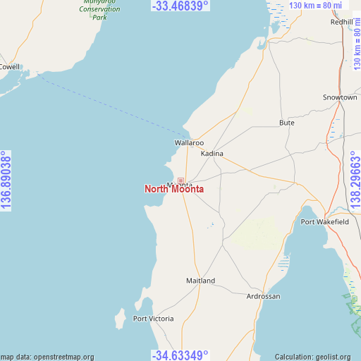
North Moonta GPS coordinates[2]
34° 3' 10.584" South, 137° 35' 36.6" East
| Map corner | latitude | longitude |
|---|---|---|
| Upper-left | -33.46839°, | 136.89038° |
| Center: | -34.05294°, | 137.5935° |
| Lower-right: | -34.63349°, | 138.29663° |
| Map W x H: | 129.5×129.5 km | = 80.5×80.5mi |
| max Lat: | -10.58257° ⇑60.1% North |
| North Moonta: | -34.05294° |
| min Lat: | ⇓39.9% South -43.31423° |
| min Long | North Moonta | max Long |
| 113.53327° | 137.5935° | 153.61246° |
| W 14.3%⇐ | ⇒85.7% E |
Elevation
Elevation of North Moonta is 26 m = 85 ft, and this is 96 m = 315 ft below average elevation for this country.
| Max E: |
1715 m = 5627 ft | 65.9% |
| Avg. | 122 m = 400 ft | |
| North Moonta | 26 m = 85 ft | |
Min E: |
-2 m = -7 ft | 34.1% |
See also: Australia elevation on elevation.city.
Geographical zone
North Moonta is located in South temperate zone (between Tropic of Capricorn and the Antarctic Circle). Distance of this Southern Tropic circle is 1180.4 km =733.5 mi to North.| Distance of | km | miles | from North Moonta |
|---|---|---|---|
| Equator | 3786.3 | 2352.7 | to North |
| Tropic Capricorn | 1180.4 | 733.5 | to North |
| Antarctic Circle | 3614.8 | 2246.1 | to South |
| South Pole | 6220.7 | 3865.4 | to South |


Nearby cities:
15 places around North Moonta: (largest is in red/bold)
• Ardrossan
50.8 km =31.6 mi,  143°
143°
• Arno Bay
96.2 km =59.8 mi,  280°
280°
• Balaklava
76 km =47.2 mi,  97°
97°
• Cowell
74.5 km =46.3 mi,  303°
303°
• Crystal Brook
96.5 km =60 mi,  36°
36°
• Kadina
15 km =9.3 mi,  49°
49°
• Maitland
36.4 km =22.6 mi,  168°
168°
• Mallala
94.5 km =58.7 mi,  116°
116°
• Minlaton
79.8 km =49.6 mi,  179°
179°
• Moonta
1.7 km =1.1 mi,  188°
188°
• Moonta Bay
2.5 km =1.6 mi, 277°
• Port Broughton
59.4 km =36.9 mi,  32°
32°
• Port Hughes
5.2 km =3.2 mi,  229°
229°
• Port Wakefield
52.9 km =32.9 mi,  106°
106°
• Wallaroo
13.2 km =8.2 mi,  16°
16°
Sources, notices
• [Note1] Compared only with cities in Australia existing in our database
• [Src1] Map data: © OpenStreetMap contributors (CC-BY-SA)
• [Src2] Other city data from geonames.org with taken over terms of usage.
• [Src3] Geographical zone / Annual Mean Temperature by Robert A. Rohde @ Wikipedia
