Port Wakefield geodata
Port Wakefield (South Australia) is a populated place; located in Australia in Australia/Adelaide (GMT+10.5) time zone. With population of 654 people, there are 4424 cities with bigger population in this country. Compared to other cities in Australia, 61.2% of cities are located further ↑North; 85.3% of cities are located further →East and 93.8% of cities have higher elevation than Port Wakefield. Note1


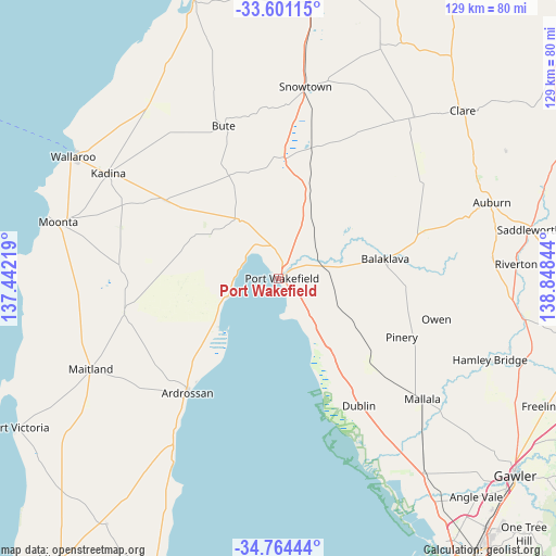
Port Wakefield GPS coordinates[2]
34° 11' 5.28" South, 138° 8' 43.116" East
| Map corner | latitude | longitude |
|---|---|---|
| Upper-left | -33.60115°, | 137.44219° |
| Center: | -34.1848°, | 138.14531° |
| Lower-right: | -34.76444°, | 138.84844° |
| Map W x H: | 129.3×129.3 km | = 80.3×80.3mi |
| max Lat: | -10.58257° ⇑61.2% North |
| Port Wakefield: | -34.1848° |
| min Lat: | ⇓38.8% South -43.31423° |
| min Long | Port Wakefield | max Long |
| 113.53327° | 138.14531° | 153.61246° |
| W 14.7%⇐ | ⇒85.3% E |
Elevation
Elevation of Port Wakefield is 7 m = 23 ft, and this is 115 m = 377 ft below average elevation for this country.
| Max E: |
1715 m = 5627 ft | 93.8% |
| Avg. | 122 m = 400 ft | |
| Port Wakefield | 7 m = 23 ft | |
Min E: |
-2 m = -7 ft | 6.2% |
See also: Australia elevation on elevation.city.
Geographical zone
Port Wakefield is located in South temperate zone (between Tropic of Capricorn and the Antarctic Circle). Distance of this Southern Tropic circle is 1195.1 km =742.6 mi to North.| Distance of | km | miles | from Port Wakefield |
|---|---|---|---|
| Equator | 3801 | 2361.8 | to North |
| Tropic Capricorn | 1195.1 | 742.6 | to North |
| Antarctic Circle | 3600.2 | 2237.1 | to South |
| South Pole | 6206.1 | 3856.3 | to South |


Nearby cities:
15 places around Port Wakefield: (largest is in red/bold)
• Ardrossan
33.6 km =20.9 mi,  218°
218°
• Auburn
52.7 km =32.7 mi,  70°
70°
• Balaklava
24.9 km =15.5 mi,  79°
79°
• Clare
58 km =36 mi,  47°
47°
• Hamley Bridge
52.8 km =32.8 mi,  111°
111°
• Kadina
46.5 km =28.9 mi,  301°
301°
• Maitland
48.2 km =30 mi,  244°
244°
• Mallala
43.7 km =27.2 mi,  129°
129°
• Moonta
52.7 km =32.7 mi,  284°
284°
• Moonta Bay
55.3 km =34.4 mi,  285°
285°
• North Moonta
52.9 km =32.9 mi, 286°
• Port Hughes
55.9 km =34.7 mi, 281°
• Riverton
55.6 km =34.5 mi,  86°
86°
• Two Wells
56.6 km =35.2 mi,  143°
143°
• Wallaroo
54.5 km =33.9 mi, 300°
Sources, notices
• [Note1] Compared only with cities in Australia existing in our database
• [Src1] Map data: © OpenStreetMap contributors (CC-BY-SA)
• [Src2] Other city data from geonames.org with taken over terms of usage.
• [Src3] Geographical zone / Annual Mean Temperature by Robert A. Rohde @ Wikipedia
