Moonta geodata
Moonta (South Australia) is a populated place; located in Australia in Australia/Adelaide (GMT+10.5) time zone. With population of 608 people, there are 4547 cities with bigger population in this country. Compared to other cities in Australia, 60.4% of cities are located further ↑North; 85.8% of cities are located further →East and 62.8% of cities have higher elevation than Moonta. Note1


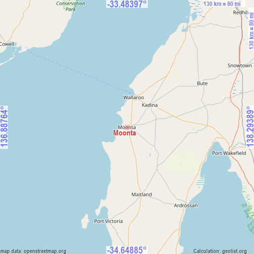
Moonta GPS coordinates[2]
34° 4' 6.276" South, 137° 35' 26.736" East
| Map corner | latitude | longitude |
|---|---|---|
| Upper-left | -33.48397°, | 136.88764° |
| Center: | -34.06841°, | 137.59076° |
| Lower-right: | -34.64885°, | 138.29389° |
| Map W x H: | 129.5×129.5 km | = 80.5×80.5mi |
| max Lat: | -10.58257° ⇑60.4% North |
| Moonta: | -34.06841° |
| min Lat: | ⇓39.6% South -43.31423° |
| min Long | Moonta | max Long |
| 113.53327° | 137.59076° | 153.61246° |
| W 14.2%⇐ | ⇒85.8% E |
Elevation
Elevation of Moonta is 29 m = 95 ft, and this is 93 m = 305 ft below average elevation for this country.
| Max E: |
1715 m = 5627 ft | 62.8% |
| Avg. | 122 m = 400 ft | |
| Moonta | 29 m = 95 ft | |
Min E: |
-2 m = -7 ft | 37.2% |
See also: Australia elevation on elevation.city.
Geographical zone
Moonta is located in South temperate zone (between Tropic of Capricorn and the Antarctic Circle). Distance of this Southern Tropic circle is 1182.1 km =734.5 mi to North.| Distance of | km | miles | from Moonta |
|---|---|---|---|
| Equator | 3788.1 | 2353.8 | to North |
| Tropic Capricorn | 1182.1 | 734.5 | to North |
| Antarctic Circle | 3613.1 | 2245.1 | to South |
| South Pole | 6219 | 3864.3 | to South |


Nearby cities:
15 places around Moonta: (largest is in red/bold)
• Ardrossan
49.6 km =30.8 mi,  142°
142°
• Arno Bay
96.3 km =59.8 mi,  281°
281°
• Balaklava
76 km =47.2 mi,  96°
96°
• Cowell
75.3 km =46.8 mi,  304°
304°
• Kadina
16.3 km =10.1 mi,  45°
45°
• Maitland
34.8 km =21.6 mi,  167°
167°
• Mallala
93.9 km =58.3 mi,  115°
115°
• Minlaton
78.1 km =48.5 mi,  179°
179°
• Moonta Bay
3 km =1.9 mi,  312°
312°
• North Moonta
1.7 km =1.1 mi,  8°
8°
• Port Broughton
61 km =37.9 mi,  31°
31°
• Port Hughes
4.1 km =2.5 mi,  246°
246°
• Port Wakefield
52.7 km =32.7 mi, 104°
• Stansbury
95.6 km =59.4 mi, 168°
• Wallaroo
14.9 km =9.3 mi,  15°
15°
Sources, notices
• [Note1] Compared only with cities in Australia existing in our database
• [Src1] Map data: © OpenStreetMap contributors (CC-BY-SA)
• [Src2] Other city data from geonames.org with taken over terms of usage.
• [Src3] Geographical zone / Annual Mean Temperature by Robert A. Rohde @ Wikipedia
