Waikerie geodata
Waikerie (South Australia) is a populated place; located in Australia in Australia/Adelaide (GMT+10.5) time zone. With population of 2,701 people, there are 2432 cities with bigger population in this country. Compared to other cities in Australia, 61.1% of cities are located further ↑North; 76.1% of cities are located further →East and 52.8% of cities have lower elevation than Waikerie. Note1


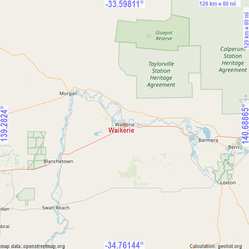
Waikerie GPS coordinates[2]
34° 10' 54.408" South, 139° 59' 7.872" East
| Map corner | latitude | longitude |
|---|---|---|
| Upper-left | -33.59811°, | 139.2824° |
| Center: | -34.18178°, | 139.98552° |
| Lower-right: | -34.76144°, | 140.68865° |
| Map W x H: | 129.4×129.3 km | = 80.4×80.3mi |
| max Lat: | -10.58257° ⇑61.1% North |
| Waikerie: | -34.18178° |
| min Lat: | ⇓38.9% South -43.31423° |
| min Long | Waikerie | max Long |
| 113.53327° | 139.98552° | 153.61246° |
| W 23.9%⇐ | ⇒76.1% E |
Elevation
Elevation of Waikerie is 49 m = 161 ft, and this is 73 m = 240 ft below average elevation for this country.
| Max E: |
1715 m = 5627 ft | 47.2% |
| Avg. | 122 m = 400 ft | |
| Waikerie | 49 m = 161 ft | |
Min E: |
-2 m = -7 ft | 52.8% |
See also: Australia elevation on elevation.city.
Geographical zone
Waikerie is located in South temperate zone (between Tropic of Capricorn and the Antarctic Circle). Distance of this Southern Tropic circle is 1194.7 km =742.4 mi to North.| Distance of | km | miles | from Waikerie |
|---|---|---|---|
| Equator | 3800.7 | 2361.6 | to North |
| Tropic Capricorn | 1194.7 | 742.4 | to North |
| Antarctic Circle | 3600.5 | 2237.2 | to South |
| South Pole | 6206.4 | 3856.5 | to South |


Nearby cities:
15 places around Waikerie: (largest is in red/bold)
• Barmera
44.5 km =27.7 mi,  100°
100°
• Berri
57.5 km =35.7 mi, 101°
• Cadell
25.9 km =16.1 mi,  307°
307°
• Eudunda
82.9 km =51.5 mi,  270°
270°
• Glossop
52.1 km =32.4 mi, 101°
• Kingston
34 km =21.1 mi, 99°
• Loveday
42.7 km =26.5 mi,  105°
105°
• Loxton
61.3 km =38.1 mi,  119°
119°
• Loxton North
63.9 km =39.7 mi, 114°
• Monash
53.3 km =33.1 mi, 96°
• Paringa
73.6 km =45.7 mi,  89°
89°
• Renmark
70 km =43.5 mi, 89°
• Renmark North
67.2 km =41.8 mi,  84°
84°
• Renmark West
66.6 km =41.4 mi, 88°
• Truro
82.8 km =51.4 mi,  252°
252°
Sources, notices
• [Note1] Compared only with cities in Australia existing in our database
• [Src1] Map data: © OpenStreetMap contributors (CC-BY-SA)
• [Src2] Other city data from geonames.org with taken over terms of usage.
• [Src3] Geographical zone / Annual Mean Temperature by Robert A. Rohde @ Wikipedia
