Loveday geodata
Loveday (South Australia) is a populated place; located in Australia in Australia/Adelaide (GMT+10.5) time zone. With population of 615 people, there are 4532 cities with bigger population in this country. Compared to other cities in Australia, 61.7% of cities are located further ↑North; 76% of cities are located further →East and 59.2% of cities have higher elevation than Loveday. Note1


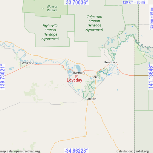
Loveday GPS coordinates[2]
34° 16' 59.988" South, 140° 25' 59.988" East
| Map corner | latitude | longitude |
|---|---|---|
| Upper-left | -33.70036°, | 139.73021° |
| Center: | -34.28333°, | 140.43333° |
| Lower-right: | -34.86228°, | 141.13646° |
| Map W x H: | 129.2×129.2 km | = 80.3×80.3mi |
| max Lat: | -10.58257° ⇑61.7% North |
| Loveday: | -34.28333° |
| min Lat: | ⇓38.3% South -43.31423° |
| min Long | Loveday | max Long |
| 113.53327° | 140.43333° | 153.61246° |
| W 24%⇐ | ⇒76% E |
Elevation
Elevation of Loveday is 33 m = 108 ft, and this is 89 m = 292 ft below average elevation for this country.
| Max E: |
1715 m = 5627 ft | 59.2% |
| Avg. | 122 m = 400 ft | |
| Loveday | 33 m = 108 ft | |
Min E: |
-2 m = -7 ft | 40.8% |
See also: Australia elevation on elevation.city.
Geographical zone
Loveday is located in South temperate zone (between Tropic of Capricorn and the Antarctic Circle). Distance of this Southern Tropic circle is 1206 km =749.4 mi to North.| Distance of | km | miles | from Loveday |
|---|---|---|---|
| Equator | 3811.9 | 2368.6 | to North |
| Tropic Capricorn | 1206 | 749.4 | to North |
| Antarctic Circle | 3589.2 | 2230.2 | to South |
| South Pole | 6195.1 | 3849.5 | to South |


Nearby cities:
15 places around Loveday: (largest is in red/bold)
• Barmera
4 km =2.5 mi,  40°
40°
• Berri
15.3 km =9.5 mi,  89°
89°
• Cadell
67.3 km =41.8 mi,  293°
293°
• Glossop
9.9 km =6.2 mi, 85°
• Karoonda
102.8 km =63.9 mi,  208°
208°
• Kingston
9.5 km =5.9 mi,  305°
305°
• Lameroo
116.5 km =72.4 mi,  176°
176°
• Loxton
22.3 km =13.9 mi,  146°
146°
• Loxton North
22.7 km =14.1 mi,  130°
130°
• Monash
12.8 km =8 mi,  66°
66°
• Paringa
34.5 km =21.4 mi, 69°
• Renmark
31.2 km =19.4 mi, 67°
• Renmark North
31.1 km =19.3 mi,  55°
55°
• Renmark West
28.6 km =17.8 mi, 62°
• Waikerie
42.7 km =26.5 mi, 285°
Sources, notices
• [Note1] Compared only with cities in Australia existing in our database
• [Src1] Map data: © OpenStreetMap contributors (CC-BY-SA)
• [Src2] Other city data from geonames.org with taken over terms of usage.
• [Src3] Geographical zone / Annual Mean Temperature by Robert A. Rohde @ Wikipedia
