Renmark North geodata
Renmark North (South Australia) is a populated place; located in Australia in Australia/Adelaide (GMT+10.5) time zone. With population of 626 people, there are 4501 cities with bigger population in this country. Compared to other cities in Australia, 60.8% of cities are located further ↑North; 75.7% of cities are located further →East and 65.9% of cities have higher elevation than Renmark North. Note1


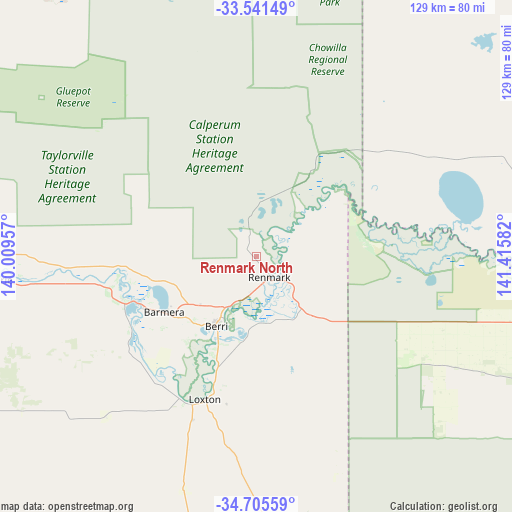
Renmark North GPS coordinates[2]
34° 7' 31.944" South, 140° 42' 45.684" East
| Map corner | latitude | longitude |
|---|---|---|
| Upper-left | -33.54149°, | 140.00957° |
| Center: | -34.12554°, | 140.71269° |
| Lower-right: | -34.70559°, | 141.41582° |
| Map W x H: | 129.4×129.4 km | = 80.4×80.4mi |
| max Lat: | -10.58257° ⇑60.8% North |
| Renmark North: | -34.12554° |
| min Lat: | ⇓39.2% South -43.31423° |
| min Long | Renmark North | max Long |
| 113.53327° | 140.71269° | 153.61246° |
| W 24.3%⇐ | ⇒75.7% E |
Elevation
Elevation of Renmark North is 26 m = 85 ft, and this is 96 m = 315 ft below average elevation for this country.
| Max E: |
1715 m = 5627 ft | 65.9% |
| Avg. | 122 m = 400 ft | |
| Renmark North | 26 m = 85 ft | |
Min E: |
-2 m = -7 ft | 34.1% |
See also: Australia elevation on elevation.city.
Geographical zone
Renmark North is located in South temperate zone (between Tropic of Capricorn and the Antarctic Circle). Distance of this Southern Tropic circle is 1188.5 km =738.5 mi to North.| Distance of | km | miles | from Renmark North |
|---|---|---|---|
| Equator | 3794.4 | 2357.7 | to North |
| Tropic Capricorn | 1188.5 | 738.5 | to North |
| Antarctic Circle | 3606.8 | 2241.2 | to South |
| South Pole | 6212.7 | 3860.4 | to South |


Nearby cities:
15 places around Renmark North: (largest is in red/bold)
• Barmera
27.3 km =17 mi,  237°
237°
• Berri
20.2 km =12.6 mi,  211°
211°
• Cadell
87.9 km =54.6 mi,  276°
276°
• Dareton
122.2 km =75.9 mi,  88°
88°
• Glossop
23.1 km =14.4 mi,  223°
223°
• Kingston
35.4 km =22 mi,  250°
250°
• Loveday
31.1 km =19.3 mi, 235°
• Loxton
38.4 km =23.9 mi,  200°
200°
• Loxton North
33.5 km =20.8 mi,  194°
194°
• Monash
18.7 km =11.6 mi,  227°
227°
• Paringa
8.8 km =5.5 mi,  130°
130°
• Renmark
6.5 km =4 mi,  151°
151°
• Renmark West
4.4 km =2.7 mi,  183°
183°
• Waikerie
67.2 km =41.8 mi,  264°
264°
• Wentworth
110.5 km =68.7 mi, 88°
Sources, notices
• [Note1] Compared only with cities in Australia existing in our database
• [Src1] Map data: © OpenStreetMap contributors (CC-BY-SA)
• [Src2] Other city data from geonames.org with taken over terms of usage.
• [Src3] Geographical zone / Annual Mean Temperature by Robert A. Rohde @ Wikipedia
