Glossop geodata
Glossop (South Australia) is a section of populated place; located in Australia in Australia/Adelaide (GMT+10.5) time zone. With population of 992 people, there are 3837 cities with bigger population in this country. Compared to other cities in Australia, 61.6% of cities are located further ↑North; 75.9% of cities are located further →East and 55.2% of cities have higher elevation than Glossop. Note1


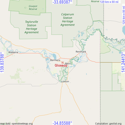
Glossop GPS coordinates[2]
34° 16' 36.768" South, 140° 32' 27.6" East
| Map corner | latitude | longitude |
|---|---|---|
| Upper-left | -33.69387°, | 139.83788° |
| Center: | -34.27688°, | 140.541° |
| Lower-right: | -34.85588°, | 141.24413° |
| Map W x H: | 129.2×129.2 km | = 80.3×80.3mi |
| max Lat: | -10.58257° ⇑61.6% North |
| Glossop: | -34.27688° |
| min Lat: | ⇓38.4% South -43.31423° |
| min Long | Glossop | max Long |
| 113.53327° | 140.541° | 153.61246° |
| W 24.1%⇐ | ⇒75.9% E |
Elevation
Elevation of Glossop is 38 m = 125 ft, and this is 84 m = 276 ft below average elevation for this country.
| Max E: |
1715 m = 5627 ft | 55.2% |
| Avg. | 122 m = 400 ft | |
| Glossop | 38 m = 125 ft | |
Min E: |
-2 m = -7 ft | 44.8% |
See also: Australia elevation on elevation.city.
Geographical zone
Glossop is located in South temperate zone (between Tropic of Capricorn and the Antarctic Circle). Distance of this Southern Tropic circle is 1205.3 km =748.9 mi to North.| Distance of | km | miles | from Glossop |
|---|---|---|---|
| Equator | 3811.2 | 2368.2 | to North |
| Tropic Capricorn | 1205.3 | 748.9 | to North |
| Antarctic Circle | 3589.9 | 2230.7 | to South |
| South Pole | 6195.8 | 3849.9 | to South |


Nearby cities:
15 places around Glossop: (largest is in red/bold)
• Barmera
7.7 km =4.8 mi,  287°
287°
• Berri
5.4 km =3.4 mi,  94°
94°
• Cadell
76.2 km =47.3 mi, 290°
• Karoonda
108.5 km =67.4 mi,  213°
213°
• Kingston
18.2 km =11.3 mi, 285°
• Loveday
9.9 km =6.2 mi,  265°
265°
• Loxton
19.4 km =12.1 mi,  172°
172°
• Loxton North
17.2 km =10.7 mi,  154°
154°
• Monash
4.7 km =2.9 mi,  23°
23°
• Paringa
25.1 km =15.6 mi,  63°
63°
• Pinnaroo
114.6 km =71.2 mi,  162°
162°
• Renmark
22 km =13.7 mi, 59°
• Renmark North
23.1 km =14.4 mi,  43°
43°
• Renmark West
19.9 km =12.4 mi,  51°
51°
• Waikerie
52.1 km =32.4 mi,  281°
281°
Sources, notices
• [Note1] Compared only with cities in Australia existing in our database
• [Src1] Map data: © OpenStreetMap contributors (CC-BY-SA)
• [Src2] Other city data from geonames.org with taken over terms of usage.
• [Src3] Geographical zone / Annual Mean Temperature by Robert A. Rohde @ Wikipedia
