Gladstone geodata
Gladstone (South Australia) is a populated place; located in Australia in Australia/Adelaide (GMT+10.5) time zone. With population of 737 people, there are 4267 cities with bigger population in this country. Compared to other cities in Australia, 55.7% of cities are located further ↓South; 85.1% of cities are located further →East and 83.9% of cities have lower elevation than Gladstone. Note1


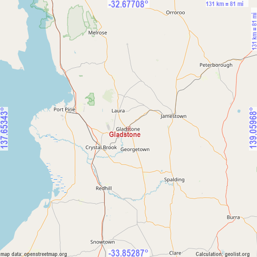
Gladstone GPS coordinates[2]
33° 16' 1.02" South, 138° 21' 23.58" East
| Map corner | latitude | longitude |
|---|---|---|
| Upper-left | -32.67708°, | 137.65343° |
| Center: | -33.26695°, | 138.35655° |
| Lower-right: | -33.85287°, | 139.05968° |
| Map W x H: | 130.7×130.7 km | = 81.2×81.2mi |
| max Lat: | -10.58257° ⇑44.3% North |
| Gladstone: | -33.26695° |
| min Lat: | ⇓55.7% South -43.31423° |
| min Long | Gladstone | max Long |
| 113.53327° | 138.35655° | 153.61246° |
| W 14.9%⇐ | ⇒85.1% E |
Elevation
Elevation of Gladstone is 229 m = 751 ft, and this is 107 m = 351 ft above average elevation for this country.
| Max E: |
1715 m = 5627 ft | 16.1% |
| Gladstone | 229 m 751 ft | |
| Avg. | 122 m = 400 ft | |
Min E: |
-2 m = -7 ft | 83.9% |
See also: Australia elevation on elevation.city.
Geographical zone
Gladstone is located in South temperate zone (between Tropic of Capricorn and the Antarctic Circle). Distance of this Southern Tropic circle is 1093 km =679.2 mi to North.| Distance of | km | miles | from Gladstone |
|---|---|---|---|
| Equator | 3698.9 | 2298.4 | to North |
| Tropic Capricorn | 1093 | 679.2 | to North |
| Antarctic Circle | 3702.2 | 2300.4 | to South |
| South Pole | 6308.1 | 3919.7 | to South |


Nearby cities:
15 places around Gladstone: (largest is in red/bold)
• Burra
69.6 km =43.2 mi,  130°
130°
• Clare
67.2 km =41.8 mi,  159°
159°
• Crystal Brook
16.6 km =10.3 mi,  235°
235°
• Jamestown
24.1 km =15 mi,  73°
73°
• Laura
10.4 km =6.5 mi,  330°
330°
• Napperby
25.4 km =15.8 mi,  298°
298°
• Orroroo
63.9 km =39.7 mi,  22°
22°
• Peterborough
55.8 km =34.7 mi,  53°
53°
• Port Broughton
53.9 km =33.5 mi,  226°
226°
• Port Pirie
32.6 km =20.3 mi,  284°
284°
• Port Pirie South
32.7 km =20.3 mi, 283°
• Port Pirie West
34.7 km =21.6 mi,  286°
286°
• Risdon Park
34.6 km =21.5 mi, 283°
• Risdon Park South
34.2 km =21.3 mi, 280°
• Solomontown
32.3 km =20.1 mi, 286°
Sources, notices
• [Note1] Compared only with cities in Australia existing in our database
• [Src1] Map data: © OpenStreetMap contributors (CC-BY-SA)
• [Src2] Other city data from geonames.org with taken over terms of usage.
• [Src3] Geographical zone / Annual Mean Temperature by Robert A. Rohde @ Wikipedia
