Jamestown geodata
Jamestown (South Australia) is a populated place; located in Australia in Australia/Adelaide (GMT+10.5) time zone. With population of 1,610 people, there are 3178 cities with bigger population in this country. Compared to other cities in Australia, 56.1% of cities are located further ↓South; 81.2% of cities are located further →East and 92.5% of cities have lower elevation than Jamestown. Note1


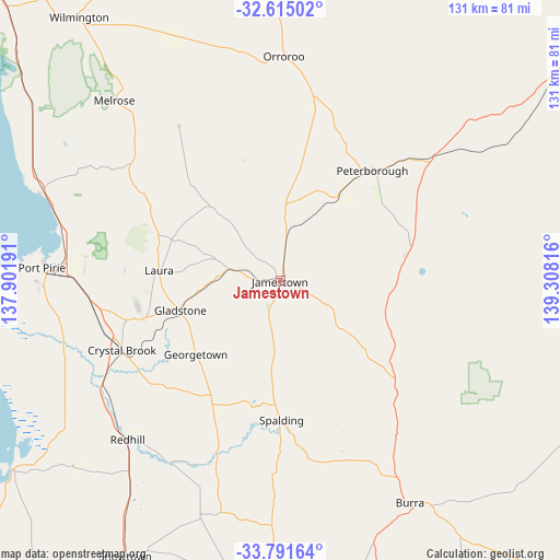
Jamestown GPS coordinates[2]
33° 12' 19.116" South, 138° 36' 18.108" East
| Map corner | latitude | longitude |
|---|---|---|
| Upper-left | -32.61502°, | 137.90191° |
| Center: | -33.20531°, | 138.60503° |
| Lower-right: | -33.79164°, | 139.30816° |
| Map W x H: | 130.8×130.8 km | = 81.3×81.3mi |
| max Lat: | -10.58257° ⇑43.9% North |
| Jamestown: | -33.20531° |
| min Lat: | ⇓56.1% South -43.31423° |
| min Long | Jamestown | max Long |
| 113.53327° | 138.60503° | 153.61246° |
| W 18.8%⇐ | ⇒81.2% E |
Elevation
Elevation of Jamestown is 456 m = 1496 ft, and this is 334 m = 1096 ft above average elevation for this country.
| Max E: |
1715 m = 5627 ft | 7.5% |
| Jamestown | 456 m 1496 ft | |
| Avg. | 122 m = 400 ft | |
Min E: |
-2 m = -7 ft | 92.5% |
See also: Australia elevation on elevation.city.
Geographical zone
Jamestown is located in South temperate zone (between Tropic of Capricorn and the Antarctic Circle). Distance of this Southern Tropic circle is 1086.2 km =674.9 mi to North.| Distance of | km | miles | from Jamestown |
|---|---|---|---|
| Equator | 3692.1 | 2294.2 | to North |
| Tropic Capricorn | 1086.2 | 674.9 | to North |
| Antarctic Circle | 3709.1 | 2304.7 | to South |
| South Pole | 6315 | 3924 | to South |


Nearby cities:
15 places around Jamestown: (largest is in red/bold)
• Burra
59.9 km =37.2 mi,  149°
149°
• Clare
69.8 km =43.4 mi,  179°
179°
• Crystal Brook
40.2 km =25 mi,  245°
245°
• Gladstone
24.1 km =15 mi, 253°
• Laura
28.3 km =17.6 mi,  274°
274°
• Napperby
45.8 km =28.5 mi,  276°
276°
• Orroroo
52.4 km =32.6 mi,  0°
0°
• Peterborough
34 km =21.1 mi,  40°
40°
• Port Broughton
76.1 km =47.3 mi,  234°
234°
• Port Pirie
54.7 km =34 mi, 271°
• Port Pirie South
55 km =34.2 mi, 270°
• Port Pirie West
56.5 km =35.1 mi, 273°
• Risdon Park
56.9 km =35.4 mi, 270°
• Risdon Park South
56.8 km =35.3 mi, 269°
• Solomontown
54.1 km =33.6 mi, 272°
Sources, notices
• [Note1] Compared only with cities in Australia existing in our database
• [Src1] Map data: © OpenStreetMap contributors (CC-BY-SA)
• [Src2] Other city data from geonames.org with taken over terms of usage.
• [Src3] Geographical zone / Annual Mean Temperature by Robert A. Rohde @ Wikipedia
