Upper Sturt geodata
Upper Sturt (South Australia) is a section of populated place; located in Australia in Australia/Adelaide (GMT+10.5) time zone. With population of 937 people, there are 3919 cities with bigger population in this country. Compared to other cities in Australia, 71.8% of cities are located further ↑North; 78.5% of cities are located further →East and 91.8% of cities have lower elevation than Upper Sturt. Note1


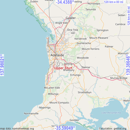
Upper Sturt GPS coordinates[2]
35° 1' 0.012" South, 138° 40' 59.988" East
| Map corner | latitude | longitude |
|---|---|---|
| Upper-left | -34.4388°, | 137.98021° |
| Center: | -35.01667°, | 138.68333° |
| Lower-right: | -35.59049°, | 139.38646° |
| Map W x H: | 128.1×128.1 km | = 79.6×79.6mi |
| max Lat: | -10.58257° ⇑71.8% North |
| Upper Sturt: | -35.01667° |
| min Lat: | ⇓28.2% South -43.31423° |
| min Long | Upper Sturt | max Long |
| 113.53327° | 138.68333° | 153.61246° |
| W 21.5%⇐ | ⇒78.5% E |
Elevation
Elevation of Upper Sturt is 434 m = 1424 ft, and this is 312 m = 1024 ft above average elevation for this country.
| Max E: |
1715 m = 5627 ft | 8.2% |
| Upper Sturt | 434 m 1424 ft | |
| Avg. | 122 m = 400 ft | |
Min E: |
-2 m = -7 ft | 91.8% |
See also: Australia elevation on elevation.city.
Geographical zone
Upper Sturt is located in South temperate zone (between Tropic of Capricorn and the Antarctic Circle). Distance of this Southern Tropic circle is 1287.6 km =800.1 mi to North.| Distance of | km | miles | from Upper Sturt |
|---|---|---|---|
| Equator | 3893.5 | 2419.3 | to North |
| Tropic Capricorn | 1287.6 | 800.1 | to North |
| Antarctic Circle | 3507.7 | 2179.6 | to South |
| South Pole | 6113.6 | 3798.8 | to South |


Nearby cities:
15 places around Upper Sturt: (largest is in red/bold)
• Aldgate
4.6 km =2.9 mi,  90°
90°
• Belair
6.1 km =3.8 mi,  290°
290°
• Blackwood
6.3 km =3.9 mi,  265°
265°
• Cherry Gardens
5.5 km =3.4 mi,  199°
199°
• Coromandel Valley
7.1 km =4.4 mi,  238°
238°
• Crafers
2.4 km =1.5 mi,  39°
39°
• Crafers West
2.8 km =1.7 mi,  357°
357°
• Glenalta
5.3 km =3.3 mi,  280°
280°
• Hawthorndene
4.9 km =3 mi,  262°
262°
• Heathfield
3.3 km =2.1 mi,  112°
112°
• Ironbank
3.7 km =2.3 mi,  180°
180°
• Mitcham
7 km =4.3 mi,  306°
306°
• Springfield
6.3 km =3.9 mi, 312°
• Stirling
3.7 km =2.3 mi,  64°
64°
• Urrbrae
6.7 km =4.2 mi,  326°
326°
Sources, notices
• [Note1] Compared only with cities in Australia existing in our database
• [Src1] Map data: © OpenStreetMap contributors (CC-BY-SA)
• [Src2] Other city data from geonames.org with taken over terms of usage.
• [Src3] Geographical zone / Annual Mean Temperature by Robert A. Rohde @ Wikipedia
