Crafers geodata
Crafers (South Australia) is a populated place; located in Australia in Australia/Adelaide (GMT+10.5) time zone. With population of 1,905 people, there are 2968 cities with bigger population in this country. Compared to other cities in Australia, 71.3% of cities are located further ↑North; 78.2% of cities are located further →East and 94.3% of cities have lower elevation than Crafers. Note1


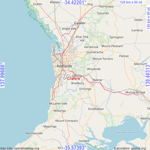
Crafers GPS coordinates[2]
35° 0' 0" South, 138° 42' 0" East
| Map corner | latitude | longitude |
|---|---|---|
| Upper-left | -34.42201°, | 137.99688° |
| Center: | -35°, | 138.7° |
| Lower-right: | -35.57393°, | 139.40313° |
| Map W x H: | 128.1×128.1 km | = 79.6×79.6mi |
| max Lat: | -10.58257° ⇑71.3% North |
| Crafers: | -35° |
| min Lat: | ⇓28.7% South -43.31423° |
| min Long | Crafers | max Long |
| 113.53327° | 138.7° | 153.61246° |
| W 21.8%⇐ | ⇒78.2% E |
Elevation
Elevation of Crafers is 559 m = 1834 ft, and this is 437 m = 1434 ft above average elevation for this country.
| Max E: |
1715 m = 5627 ft | 5.7% |
| Crafers | 559 m 1834 ft | |
| Avg. | 122 m = 400 ft | |
Min E: |
-2 m = -7 ft | 94.3% |
See also: Australia elevation on elevation.city.
Geographical zone
Crafers is located in South temperate zone (between Tropic of Capricorn and the Antarctic Circle). Distance of this Southern Tropic circle is 1285.7 km =798.9 mi to North.| Distance of | km | miles | from Crafers |
|---|---|---|---|
| Equator | 3891.6 | 2418.1 | to North |
| Tropic Capricorn | 1285.7 | 798.9 | to North |
| Antarctic Circle | 3509.5 | 2180.7 | to South |
| South Pole | 6115.4 | 3799.9 | to South |


Nearby cities:
15 places around Crafers: (largest is in red/bold)
• Aldgate
3.6 km =2.2 mi,  121°
121°
• Beaumont
6.7 km =4.2 mi,  328°
328°
• Bridgewater
6.3 km =3.9 mi,  104°
104°
• Crafers West
1.9 km =1.2 mi,  300°
300°
• Glen Osmond
6.5 km =4 mi,  313°
313°
• Glenalta
6.8 km =4.2 mi,  262°
262°
• Hawthorndene
6.8 km =4.2 mi,  248°
248°
• Heathfield
3.5 km =2.2 mi,  153°
153°
• Ironbank
5.8 km =3.6 mi,  195°
195°
• Springfield
6.6 km =4.1 mi,  291°
291°
• Stirling
1.8 km =1.1 mi, 97°
• Summertown
5.3 km =3.3 mi,  32°
32°
• Upper Sturt
2.4 km =1.5 mi,  219°
219°
• Uraidla
6.4 km =4 mi,  39°
39°
• Urrbrae
6.5 km =4 mi, 305°
Sources, notices
• [Note1] Compared only with cities in Australia existing in our database
• [Src1] Map data: © OpenStreetMap contributors (CC-BY-SA)
• [Src2] Other city data from geonames.org with taken over terms of usage.
• [Src3] Geographical zone / Annual Mean Temperature by Robert A. Rohde @ Wikipedia
