Chittering geodata
Chittering (Western Australia) is a populated place; located in Australia in Australia/Perth (GMT+8) time zone. With population of 896 people, there are 3978 cities with bigger population in this country. Compared to other cities in Australia, 69.7% of cities are located further ↓South; 91.6% of cities are located further →East and 81.9% of cities have lower elevation than Chittering. Note1


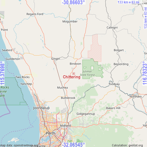
Chittering GPS coordinates[2]
31° 28' 3.576" South, 116° 4' 48.36" East
| Map corner | latitude | longitude |
|---|---|---|
| Upper-left | -30.86603°, | 115.37698° |
| Center: | -31.46766°, | 116.0801° |
| Lower-right: | -32.06545°, | 116.78323° |
| Map W x H: | 133.4×133.4 km | = 82.9×82.9mi |
| max Lat: | -10.58257° ⇑30.3% North |
| Chittering: | -31.46766° |
| min Lat: | ⇓69.7% South -43.31423° |
| min Long | Chittering | max Long |
| 113.53327° | 116.0801° | 153.61246° |
| W 8.4%⇐ | ⇒91.6% E |
Elevation
Elevation of Chittering is 203 m = 666 ft, and this is 81 m = 266 ft above average elevation for this country.
| Max E: |
1715 m = 5627 ft | 18.1% |
| Chittering | 203 m 666 ft | |
| Avg. | 122 m = 400 ft | |
Min E: |
-2 m = -7 ft | 81.9% |
See also: Australia elevation on elevation.city.
Geographical zone
Chittering is located in South temperate zone (between Tropic of Capricorn and the Antarctic Circle). Distance of this Southern Tropic circle is 893 km =554.9 mi to North.| Distance of | km | miles | from Chittering |
|---|---|---|---|
| Equator | 3498.9 | 2174.1 | to North |
| Tropic Capricorn | 893 | 554.9 | to North |
| Antarctic Circle | 3902.3 | 2424.8 | to South |
| South Pole | 6508.2 | 4044 | to South |


Nearby cities:
15 places around Chittering: (largest is in red/bold)
• Bindoon
9.1 km =5.7 mi,  9°
9°
• Brigadoon
33.9 km =21.1 mi,  181°
181°
• Bullsbrook
23.6 km =14.7 mi,  198°
198°
• Coondle
33 km =20.5 mi,  92°
92°
• Ellenbrook
34.9 km =21.7 mi, 197°
• Gidgegannup
33.5 km =20.8 mi,  162°
162°
• Gingin
21.4 km =13.3 mi,  308°
308°
• Lower Chittering
13.3 km =8.3 mi, 164°
• Mariginiup
35.2 km =21.9 mi,  219°
219°
• Morangup
30 km =18.6 mi,  138°
138°
• Muchea
16.4 km =10.2 mi, 218°
• Pearce
22.9 km =14.2 mi, 195°
• The Vines
32.8 km =20.4 mi,  192°
192°
• Upper Swan
33.9 km =21.1 mi, 188°
• West Toodyay
32.7 km =20.3 mi,  102°
102°
Sources, notices
• [Note1] Compared only with cities in Australia existing in our database
• [Src1] Map data: © OpenStreetMap contributors (CC-BY-SA)
• [Src2] Other city data from geonames.org with taken over terms of usage.
• [Src3] Geographical zone / Annual Mean Temperature by Robert A. Rohde @ Wikipedia
