Springton geodata
Springton (South Australia) is a populated place; located in Australia in Australia/Adelaide (GMT+10.5) time zone. With population of 644 people, there are 4460 cities with bigger population in this country. Compared to other cities in Australia, 64.9% of cities are located further ↑North; 76.6% of cities are located further →East and 90.5% of cities have lower elevation than Springton. Note1


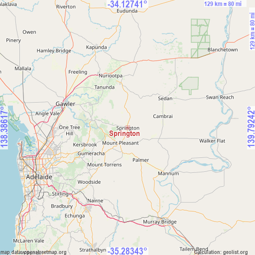
Springton GPS coordinates[2]
34° 42' 26.784" South, 139° 5' 21.444" East
| Map corner | latitude | longitude |
|---|---|---|
| Upper-left | -34.12741°, | 138.38617° |
| Center: | -34.70744°, | 139.08929° |
| Lower-right: | -35.28343°, | 139.79242° |
| Map W x H: | 128.5×128.5 km | = 79.8×79.8mi |
| max Lat: | -10.58257° ⇑64.9% North |
| Springton: | -34.70744° |
| min Lat: | ⇓35.1% South -43.31423° |
| min Long | Springton | max Long |
| 113.53327° | 139.08929° | 153.61246° |
| W 23.4%⇐ | ⇒76.6% E |
Elevation
Elevation of Springton is 391 m = 1283 ft, and this is 269 m = 883 ft above average elevation for this country.
| Max E: |
1715 m = 5627 ft | 9.5% |
| Springton | 391 m 1283 ft | |
| Avg. | 122 m = 400 ft | |
Min E: |
-2 m = -7 ft | 90.5% |
See also: Australia elevation on elevation.city.
Geographical zone
Springton is located in South temperate zone (between Tropic of Capricorn and the Antarctic Circle). Distance of this Southern Tropic circle is 1253.2 km =778.7 mi to North.| Distance of | km | miles | from Springton |
|---|---|---|---|
| Equator | 3859.1 | 2397.9 | to North |
| Tropic Capricorn | 1253.2 | 778.7 | to North |
| Antarctic Circle | 3542.1 | 2201 | to South |
| South Pole | 6148 | 3820.2 | to South |


Nearby cities:
15 places around Springton: (largest is in red/bold)
• Angaston
23.3 km =14.5 mi,  350°
350°
• Birdwood
16.8 km =10.4 mi,  222°
222°
• Charleston
29 km =18 mi, 216°
• Cockatoo Valley
24.9 km =15.5 mi,  291°
291°
• Gumeracha
22.7 km =14.1 mi,  235°
235°
• Kersbrook
23.3 km =14.5 mi,  248°
248°
• Lobethal
29.4 km =18.3 mi, 221°
• Lyndoch
21.6 km =13.4 mi,  303°
303°
• Mannum
30.3 km =18.8 mi,  139°
139°
• Mount Pleasant
8.3 km =5.2 mi,  206°
206°
• Mount Torrens
22.2 km =13.8 mi, 212°
• Nuriootpa
27.9 km =17.3 mi,  342°
342°
• One Tree Hill
29.5 km =18.3 mi,  271°
271°
• Tanunda
23.6 km =14.7 mi,  329°
329°
• Williamstown
18.5 km =11.5 mi,  282°
282°
Sources, notices
• [Note1] Compared only with cities in Australia existing in our database
• [Src1] Map data: © OpenStreetMap contributors (CC-BY-SA)
• [Src2] Other city data from geonames.org with taken over terms of usage.
• [Src3] Geographical zone / Annual Mean Temperature by Robert A. Rohde @ Wikipedia
