Hawthorndene geodata
Hawthorndene (South Australia) is a section of populated place; located in Australia in Australia/Adelaide (GMT+10.5) time zone. With population of 3,157 people, there are 2156 cities with bigger population in this country. Compared to other cities in Australia, 71.9% of cities are located further ↑North; 80.3% of cities are located further →East and 84.6% of cities have lower elevation than Hawthorndene. Note1


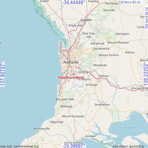
Hawthorndene GPS coordinates[2]
35° 1' 20.244" South, 138° 37' 49.404" East
| Map corner | latitude | longitude |
|---|---|---|
| Upper-left | -34.44446°, | 137.92727° |
| Center: | -35.02229°, | 138.63039° |
| Lower-right: | -35.59607°, | 139.33352° |
| Map W x H: | 128×128 km | = 79.5×79.5mi |
| max Lat: | -10.58257° ⇑71.9% North |
| Hawthorndene: | -35.02229° |
| min Lat: | ⇓28.1% South -43.31423° |
| min Long | Hawthorndene | max Long |
| 113.53327° | 138.63039° | 153.61246° |
| W 19.7%⇐ | ⇒80.3% E |
Elevation
Elevation of Hawthorndene is 241 m = 791 ft, and this is 119 m = 390 ft above average elevation for this country.
| Max E: |
1715 m = 5627 ft | 15.4% |
| Hawthorndene | 241 m 791 ft | |
| Avg. | 122 m = 400 ft | |
Min E: |
-2 m = -7 ft | 84.6% |
See also: Australia elevation on elevation.city.
Geographical zone
Hawthorndene is located in South temperate zone (between Tropic of Capricorn and the Antarctic Circle). Distance of this Southern Tropic circle is 1288.2 km =800.5 mi to North.| Distance of | km | miles | from Hawthorndene |
|---|---|---|---|
| Equator | 3894.1 | 2419.7 | to North |
| Tropic Capricorn | 1288.2 | 800.5 | to North |
| Antarctic Circle | 3507.1 | 2179.2 | to South |
| South Pole | 6112.9 | 3798.4 | to South |


Nearby cities:
15 places around Hawthorndene: (largest is in red/bold)
• Belair
2.9 km =1.8 mi,  342°
342°
• Bellevue Heights
4.4 km =2.7 mi,  258°
258°
• Blackwood
1.5 km =0.9 mi,  273°
273°
• Clapham
4.5 km =2.8 mi,  323°
323°
• Colonel Light Gardens
5 km =3.1 mi, 323°
• Coromandel Valley
3.3 km =2.1 mi,  202°
202°
• Craigburn Farm
3.1 km =1.9 mi,  228°
228°
• Eden Hills
3.2 km =2 mi, 272°
• Glenalta
1.6 km =1 mi,  345°
345°
• Mitcham
4.9 km =3 mi, 350°
• Panorama
4.5 km =2.8 mi, 321°
• Pasadena
4.4 km =2.7 mi,  299°
299°
• Springfield
4.9 km =3 mi,  2°
2°
• St Marys
5 km =3.1 mi,  293°
293°
• Upper Sturt
4.9 km =3 mi,  82°
82°
Sources, notices
• [Note1] Compared only with cities in Australia existing in our database
• [Src1] Map data: © OpenStreetMap contributors (CC-BY-SA)
• [Src2] Other city data from geonames.org with taken over terms of usage.
• [Src3] Geographical zone / Annual Mean Temperature by Robert A. Rohde @ Wikipedia
