Hamley Bridge geodata
Hamley Bridge (South Australia) is a populated place; located in Australia in Australia/Adelaide (GMT+10.5) time zone. With population of 705 people, there are 4319 cities with bigger population in this country. Compared to other cities in Australia, 62.1% of cities are located further ↑North; 78.6% of cities are located further →East and 72% of cities have lower elevation than Hamley Bridge. Note1


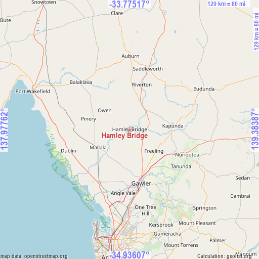
Hamley Bridge GPS coordinates[2]
34° 21' 27.468" South, 138° 40' 50.664" East
| Map corner | latitude | longitude |
|---|---|---|
| Upper-left | -33.77517°, | 137.97762° |
| Center: | -34.35763°, | 138.68074° |
| Lower-right: | -34.93607°, | 139.38387° |
| Map W x H: | 129.1×129.1 km | = 80.2×80.2mi |
| max Lat: | -10.58257° ⇑62.1% North |
| Hamley Bridge: | -34.35763° |
| min Lat: | ⇓37.9% South -43.31423° |
| min Long | Hamley Bridge | max Long |
| 113.53327° | 138.68074° | 153.61246° |
| W 21.4%⇐ | ⇒78.6% E |
Elevation
Elevation of Hamley Bridge is 112 m = 367 ft, and this is 10 m = 33 ft below average elevation for this country.
| Max E: |
1715 m = 5627 ft | 28% |
| Avg. | 122 m = 400 ft | |
| Hamley Bridge | 112 m = 367 ft | |
Min E: |
-2 m = -7 ft | 72% |
See also: Australia elevation on elevation.city.
Geographical zone
Hamley Bridge is located in South temperate zone (between Tropic of Capricorn and the Antarctic Circle). Distance of this Southern Tropic circle is 1214.3 km =754.5 mi to North.| Distance of | km | miles | from Hamley Bridge |
|---|---|---|---|
| Equator | 3820.2 | 2373.8 | to North |
| Tropic Capricorn | 1214.3 | 754.5 | to North |
| Antarctic Circle | 3581 | 2225.1 | to South |
| South Pole | 6186.9 | 3844.4 | to South |


Nearby cities:
15 places around Hamley Bridge: (largest is in red/bold)
• Freeling
15.9 km =9.9 mi,  132°
132°
• Gawler
27.9 km =17.3 mi,  167°
167°
• Gawler East
27.9 km =17.3 mi,  164°
164°
• Gawler South
28.3 km =17.6 mi, 168°
• Gawler West
27.8 km =17.3 mi, 170°
• Gawler city centre
27.2 km =16.9 mi, 167°
• Greenock
25.2 km =15.7 mi,  116°
116°
• Hewett
25.4 km =15.8 mi, 164°
• Kapunda
21.7 km =13.5 mi,  84°
84°
• Lewiston
28.6 km =17.8 mi,  196°
196°
• Mallala
18 km =11.2 mi,  240°
240°
• Riverton
23.4 km =14.5 mi,  15°
15°
• Roseworthy
20.6 km =12.8 mi, 161°
• Wasleys
12.5 km =7.8 mi,  177°
177°
• Willaston
26 km =16.2 mi, 167°
Sources, notices
• [Note1] Compared only with cities in Australia existing in our database
• [Src1] Map data: © OpenStreetMap contributors (CC-BY-SA)
• [Src2] Other city data from geonames.org with taken over terms of usage.
• [Src3] Geographical zone / Annual Mean Temperature by Robert A. Rohde @ Wikipedia
