Kapunda geodata
Kapunda (South Australia) is a populated place; located in Australia in Australia/Adelaide (GMT+10.5) time zone. With population of 2,911 people, there are 2308 cities with bigger population in this country. Compared to other cities in Australia, 62% of cities are located further ↑North; 76.9% of cities are located further →East and 85.5% of cities have lower elevation than Kapunda. Note1


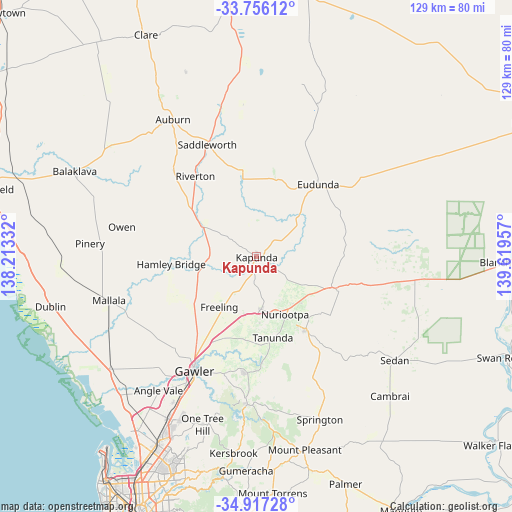
Kapunda GPS coordinates[2]
34° 20' 19.356" South, 138° 54' 59.184" East
| Map corner | latitude | longitude |
|---|---|---|
| Upper-left | -33.75612°, | 138.21332° |
| Center: | -34.33871°, | 138.91644° |
| Lower-right: | -34.91728°, | 139.61957° |
| Map W x H: | 129.1×129.1 km | = 80.2×80.2mi |
| max Lat: | -10.58257° ⇑62% North |
| Kapunda: | -34.33871° |
| min Lat: | ⇓38% South -43.31423° |
| min Long | Kapunda | max Long |
| 113.53327° | 138.91644° | 153.61246° |
| W 23.1%⇐ | ⇒76.9% E |
Elevation
Elevation of Kapunda is 256 m = 840 ft, and this is 134 m = 440 ft above average elevation for this country.
| Max E: |
1715 m = 5627 ft | 14.5% |
| Kapunda | 256 m 840 ft | |
| Avg. | 122 m = 400 ft | |
Min E: |
-2 m = -7 ft | 85.5% |
See also: Australia elevation on elevation.city.
Geographical zone
Kapunda is located in South temperate zone (between Tropic of Capricorn and the Antarctic Circle). Distance of this Southern Tropic circle is 1212.2 km =753.2 mi to North.| Distance of | km | miles | from Kapunda |
|---|---|---|---|
| Equator | 3818.1 | 2372.5 | to North |
| Tropic Capricorn | 1212.2 | 753.2 | to North |
| Antarctic Circle | 3583.1 | 2226.4 | to South |
| South Pole | 6189 | 3845.7 | to South |


Nearby cities:
15 places around Kapunda: (largest is in red/bold)
• Angaston
21.6 km =13.4 mi,  146°
146°
• Eudunda
23.7 km =14.7 mi,  40°
40°
• Freeling
16.2 km =10.1 mi,  217°
217°
• Gawler East
32.2 km =20 mi,  205°
205°
• Greenock
13.2 km =8.2 mi,  175°
175°
• Hamley Bridge
21.7 km =13.5 mi,  264°
264°
• Hewett
30.6 km =19 mi, 209°
• Lyndoch
29.3 km =18.2 mi, 184°
• Nuriootpa
16.2 km =10.1 mi, 152°
• Riverton
25.6 km =15.9 mi,  322°
322°
• Roseworthy
26.5 km =16.5 mi, 215°
• Tanunda
20.9 km =13 mi,  169°
169°
• Truro
20.9 km =13 mi,  111°
111°
• Wasleys
25.7 km =16 mi,  235°
235°
• Willaston
31.9 km =19.8 mi, 210°
Sources, notices
• [Note1] Compared only with cities in Australia existing in our database
• [Src1] Map data: © OpenStreetMap contributors (CC-BY-SA)
• [Src2] Other city data from geonames.org with taken over terms of usage.
• [Src3] Geographical zone / Annual Mean Temperature by Robert A. Rohde @ Wikipedia
