Greenock geodata
Greenock (South Australia) is a populated place; located in Australia in Australia/Adelaide (GMT+10.5) time zone. With population of 1,060 people, there are 3742 cities with bigger population in this country. Compared to other cities in Australia, 63% of cities are located further ↑North; 76.8% of cities are located further →East and 86.1% of cities have lower elevation than Greenock. Note1


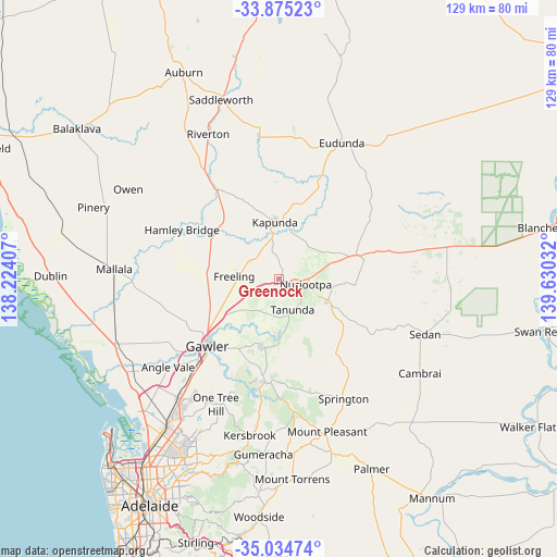
Greenock GPS coordinates[2]
34° 27' 25.2" South, 138° 55' 37.884" East
| Map corner | latitude | longitude |
|---|---|---|
| Upper-left | -33.87523°, | 138.22407° |
| Center: | -34.457°, | 138.92719° |
| Lower-right: | -35.03474°, | 139.63032° |
| Map W x H: | 128.9×128.9 km | = 80.1×80.1mi |
| max Lat: | -10.58257° ⇑63% North |
| Greenock: | -34.457° |
| min Lat: | ⇓37% South -43.31423° |
| min Long | Greenock | max Long |
| 113.53327° | 138.92719° | 153.61246° |
| W 23.2%⇐ | ⇒76.8% E |
Elevation
Elevation of Greenock is 269 m = 883 ft, and this is 147 m = 482 ft above average elevation for this country.
| Max E: |
1715 m = 5627 ft | 13.9% |
| Greenock | 269 m 883 ft | |
| Avg. | 122 m = 400 ft | |
Min E: |
-2 m = -7 ft | 86.1% |
See also: Australia elevation on elevation.city.
Geographical zone
Greenock is located in South temperate zone (between Tropic of Capricorn and the Antarctic Circle). Distance of this Southern Tropic circle is 1225.3 km =761.4 mi to North.| Distance of | km | miles | from Greenock |
|---|---|---|---|
| Equator | 3831.3 | 2380.7 | to North |
| Tropic Capricorn | 1225.3 | 761.4 | to North |
| Antarctic Circle | 3569.9 | 2218.2 | to South |
| South Pole | 6175.8 | 3837.5 | to South |


Nearby cities:
15 places around Greenock: (largest is in red/bold)
• Angaston
12 km =7.5 mi,  114°
114°
• Cockatoo Valley
20.4 km =12.7 mi,  203°
203°
• Freeling
10.9 km =6.8 mi,  271°
271°
• Gawler
23 km =14.3 mi,  225°
225°
• Gawler East
21.8 km =13.5 mi,  223°
223°
• Gawler city centre
22.8 km =14.2 mi, 227°
• Hewett
20.9 km =13 mi, 229°
• Kapunda
13.2 km =8.2 mi,  355°
355°
• Lyndoch
16.4 km =10.2 mi,  191°
191°
• Nuriootpa
6.6 km =4.1 mi,  100°
100°
• Roseworthy
18.3 km =11.4 mi,  242°
242°
• Tanunda
8 km =5 mi,  157°
157°
• Truro
19.1 km =11.9 mi,  73°
73°
• Wasleys
22.2 km =13.8 mi, 266°
• Willaston
22.3 km =13.9 mi, 229°
Sources, notices
• [Note1] Compared only with cities in Australia existing in our database
• [Src1] Map data: © OpenStreetMap contributors (CC-BY-SA)
• [Src2] Other city data from geonames.org with taken over terms of usage.
• [Src3] Geographical zone / Annual Mean Temperature by Robert A. Rohde @ Wikipedia
