Pemberton geodata
Pemberton (Western Australia) is a populated place; located in Australia in Australia/Perth (GMT+8) time zone. With population of 1,016 people, there are 3797 cities with bigger population in this country. Compared to other cities in Australia, 62.8% of cities are located further ↑North; 91.9% of cities are located further →East and 74.3% of cities have lower elevation than Pemberton. Note1


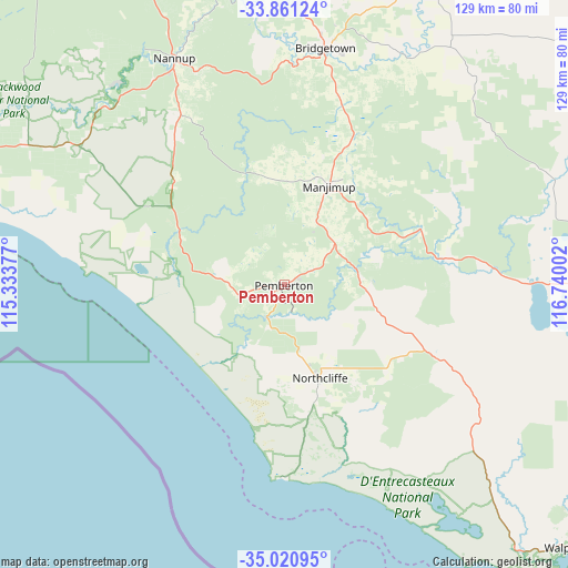
Pemberton GPS coordinates[2]
34° 26' 35.196" South, 116° 2' 12.804" East
| Map corner | latitude | longitude |
|---|---|---|
| Upper-left | -33.86124°, | 115.33377° |
| Center: | -34.44311°, | 116.03689° |
| Lower-right: | -35.02095°, | 116.74002° |
| Map W x H: | 128.9×128.9 km | = 80.1×80.1mi |
| max Lat: | -10.58257° ⇑62.8% North |
| Pemberton: | -34.44311° |
| min Lat: | ⇓37.2% South -43.31423° |
| min Long | Pemberton | max Long |
| 113.53327° | 116.03689° | 153.61246° |
| W 8.1%⇐ | ⇒91.9% E |
Elevation
Elevation of Pemberton is 125 m = 410 ft, and this is 3 m = 10 ft above average elevation for this country.
| Max E: |
1715 m = 5627 ft | 25.7% |
| Pemberton | 125 m 410 ft | |
| Avg. | 122 m = 400 ft | |
Min E: |
-2 m = -7 ft | 74.3% |
See also: Australia elevation on elevation.city.
Geographical zone
Pemberton is located in South temperate zone (between Tropic of Capricorn and the Antarctic Circle). Distance of this Southern Tropic circle is 1223.8 km =760.4 mi to North.| Distance of | km | miles | from Pemberton |
|---|---|---|---|
| Equator | 3829.7 | 2379.7 | to North |
| Tropic Capricorn | 1223.8 | 760.4 | to North |
| Antarctic Circle | 3571.5 | 2219.2 | to South |
| South Pole | 6177.3 | 3838.4 | to South |


Nearby cities:
15 places around Pemberton: (largest is in red/bold)
• Argyle
102.7 km =63.8 mi,  346°
346°
• Augusta
81.8 km =50.8 mi,  279°
279°
• Balingup
71.8 km =44.6 mi, 354°
• Boyup Brook
75 km =46.6 mi,  25°
25°
• Bridgetown
54.2 km =33.7 mi,  9°
9°
• Busselton city cenre
108.5 km =67.4 mi,  324°
324°
• Capel
107.7 km =66.9 mi,  336°
336°
• Cowaramup
108.2 km =67.2 mi,  307°
307°
• Donnybrook
98.9 km =61.5 mi, 348°
• Geographe
107.7 km =66.9 mi,  326°
326°
• Gnarabup
108 km =67.1 mi,  297°
297°
• Manjimup
24.6 km =15.3 mi,  23°
23°
• Margaret River
103.7 km =64.4 mi, 301°
• Nannup
57.4 km =35.7 mi, 334°
• Yalyalup
102.9 km =63.9 mi, 326°
Sources, notices
• [Note1] Compared only with cities in Australia existing in our database
• [Src1] Map data: © OpenStreetMap contributors (CC-BY-SA)
• [Src2] Other city data from geonames.org with taken over terms of usage.
• [Src3] Geographical zone / Annual Mean Temperature by Robert A. Rohde @ Wikipedia
