Tolga geodata
Tolga (Queensland) is a populated place; located in Australia in Australia/Brisbane (GMT+10) time zone. With population of 2,746 people, there are 2416 cities with bigger population in this country. Compared to other cities in Australia, 96.8% of cities are located further ↓South; 59.9% of cities are located further →East and 98.8% of cities have lower elevation than Tolga. Note1


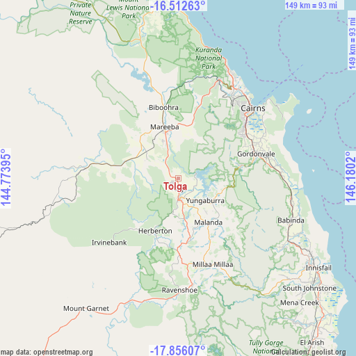
Tolga GPS coordinates[2]
17° 11' 8.052" South, 145° 28' 37.452" East
| Map corner | latitude | longitude |
|---|---|---|
| Upper-left | -16.51263°, | 144.77395° |
| Center: | -17.18557°, | 145.47707° |
| Lower-right: | -17.85607°, | 146.1802° |
| Map W x H: | 149.4×149.4 km | = 92.8×92.8mi |
| max Lat: | -10.58257° ⇑3.2% North |
| Tolga: | -17.18557° |
| min Lat: | ⇓96.8% South -43.31423° |
| min Long | Tolga | max Long |
| 113.53327° | 145.47707° | 153.61246° |
| W 40.1%⇐ | ⇒59.9% E |
Elevation
Elevation of Tolga is 758 m = 2487 ft, and this is 636 m = 2087 ft above average elevation for this country.
| Max E: |
1715 m = 5627 ft | 1.2% |
| Tolga | 758 m 2487 ft | |
| Avg. | 122 m = 400 ft | |
Min E: |
-2 m = -7 ft | 98.8% |
See also: Australia elevation on elevation.city.
Geographical zone
Tolga is located in South Torrid zone (between Equator and Tropic of Capricorn). Distance of this Southern Tropic circle is 695.1 km =431.9 mi to South.| Distance of | km | miles | from Tolga |
|---|---|---|---|
| Equator | 1910.9 | 1187.4 | to North |
| Tropic Capricorn | 695.1 | 431.9 | to South |
| Antarctic Circle | 5490.3 | 3411.5 | to South |
| South Pole | 8096.2 | 5030.7 | to South |


Nearby cities:
15 places around Tolga: (largest is in red/bold)
• Atherton
9.2 km =5.7 mi,  181°
181°
• Bentley Park
34.3 km =21.3 mi,  53°
53°
• Edmonton
33.9 km =21.1 mi,  56°
56°
• Goldsborough
27.8 km =17.3 mi,  82°
82°
• Gordonvale
33.6 km =20.9 mi,  73°
73°
• Herberton
23.1 km =14.4 mi,  205°
205°
• Koah
34.3 km =21.3 mi,  13°
13°
• Malanda
22.4 km =13.9 mi,  145°
145°
• Mareeba
22.4 km =13.9 mi,  345°
345°
• Mount Sheridan
35.1 km =21.8 mi, 50°
• Peeramon
19.9 km =12.4 mi,  134°
134°
• Speewah
36 km =22.4 mi,  23°
23°
• Walkamin
8.4 km =5.2 mi,  310°
310°
• Wondecla
27 km =16.8 mi,  197°
197°
• Yungaburra
14.7 km =9.1 mi, 129°
Sources, notices
• [Note1] Compared only with cities in Australia existing in our database
• [Src1] Map data: © OpenStreetMap contributors (CC-BY-SA)
• [Src2] Other city data from geonames.org with taken over terms of usage.
• [Src3] Geographical zone / Annual Mean Temperature by Robert A. Rohde @ Wikipedia
