Herberton geodata
Herberton (Queensland) is a populated place; located in Australia in Australia/Brisbane (GMT+10) time zone. With population of 948 people, there are 3900 cities with bigger population in this country. Compared to other cities in Australia, 96.6% of cities are located further ↓South; 60.5% of cities are located further →East and 99.4% of cities have lower elevation than Herberton. Note1


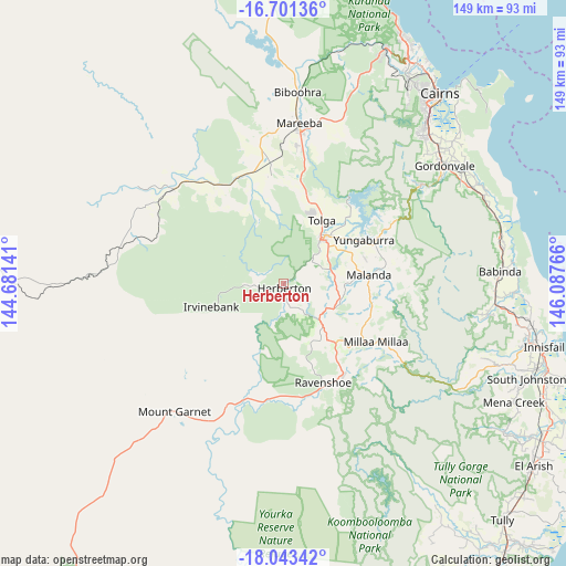
Herberton GPS coordinates[2]
17° 22' 25.032" South, 145° 23' 4.308" East
| Map corner | latitude | longitude |
|---|---|---|
| Upper-left | -16.70136°, | 144.68141° |
| Center: | -17.37362°, | 145.38453° |
| Lower-right: | -18.04342°, | 146.08766° |
| Map W x H: | 149.2×149.2 km | = 92.7×92.7mi |
| max Lat: | -10.58257° ⇑3.4% North |
| Herberton: | -17.37362° |
| min Lat: | ⇓96.6% South -43.31423° |
| min Long | Herberton | max Long |
| 113.53327° | 145.38453° | 153.61246° |
| W 39.5%⇐ | ⇒60.5% E |
Elevation
Elevation of Herberton is 912 m = 2992 ft, and this is 790 m = 2592 ft above average elevation for this country.
| Max E: |
1715 m = 5627 ft | 0.59999999999999% |
| Herberton | 912 m 2992 ft | |
| Avg. | 122 m = 400 ft | |
Min E: |
-2 m = -7 ft | 99.4% |
See also: Australia elevation on elevation.city.
Geographical zone
Herberton is located in South Torrid zone (between Equator and Tropic of Capricorn). Distance of this Southern Tropic circle is 674.2 km =418.9 mi to South.| Distance of | km | miles | from Herberton |
|---|---|---|---|
| Equator | 1931.8 | 1200.4 | to North |
| Tropic Capricorn | 674.2 | 418.9 | to South |
| Antarctic Circle | 5469.4 | 3398.5 | to South |
| South Pole | 8075.3 | 5017.8 | to South |


Nearby cities:
15 places around Herberton: (largest is in red/bold)
• Atherton
15.1 km =9.4 mi,  39°
39°
• Dimbulah
38.5 km =23.9 mi,  310°
310°
• Edmonton
54.9 km =34.1 mi, 44°
• Goldsborough
44.7 km =27.8 mi,  56°
56°
• Gordonvale
51.9 km =32.2 mi,  54°
54°
• Malanda
22.5 km =14 mi,  83°
83°
• Mareeba
42.7 km =26.5 mi,  5°
5°
• Millaa Millaa
28.8 km =17.9 mi,  122°
122°
• Millstream
31.2 km =19.4 mi,  174°
174°
• Peeramon
25.1 km =15.6 mi,  73°
73°
• Ravenshoe
28.2 km =17.5 mi,  158°
158°
• Tolga
23.1 km =14.4 mi,  25°
25°
• Walkamin
26.6 km =16.5 mi, 7°
• Wondecla
5.1 km =3.2 mi, 161°
• Yungaburra
24 km =14.9 mi, 61°
Sources, notices
• [Note1] Compared only with cities in Australia existing in our database
• [Src1] Map data: © OpenStreetMap contributors (CC-BY-SA)
• [Src2] Other city data from geonames.org with taken over terms of usage.
• [Src3] Geographical zone / Annual Mean Temperature by Robert A. Rohde @ Wikipedia
