Malanda geodata
Malanda (Queensland) is a populated place; located in Australia in Australia/Brisbane (GMT+10) time zone. With population of 2,004 people, there are 2905 cities with bigger population in this country. Compared to other cities in Australia, 96.6% of cities are located further ↓South; 59.1% of cities are located further →East and 98.6% of cities have lower elevation than Malanda. Note1


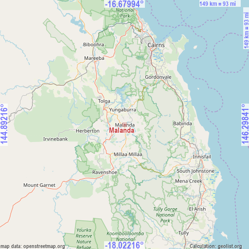
Malanda GPS coordinates[2]
17° 21' 8.208" South, 145° 35' 43.008" East
| Map corner | latitude | longitude |
|---|---|---|
| Upper-left | -16.67994°, | 144.89216° |
| Center: | -17.35228°, | 145.59528° |
| Lower-right: | -18.02216°, | 146.29841° |
| Map W x H: | 149.2×149.2 km | = 92.7×92.7mi |
| max Lat: | -10.58257° ⇑3.4% North |
| Malanda: | -17.35228° |
| min Lat: | ⇓96.6% South -43.31423° |
| min Long | Malanda | max Long |
| 113.53327° | 145.59528° | 153.61246° |
| W 40.9%⇐ | ⇒59.1% E |
Elevation
Elevation of Malanda is 740 m = 2428 ft, and this is 618 m = 2028 ft above average elevation for this country.
| Max E: |
1715 m = 5627 ft | 1.4% |
| Malanda | 740 m 2428 ft | |
| Avg. | 122 m = 400 ft | |
Min E: |
-2 m = -7 ft | 98.6% |
See also: Australia elevation on elevation.city.
Geographical zone
Malanda is located in South Torrid zone (between Equator and Tropic of Capricorn). Distance of this Southern Tropic circle is 676.5 km =420.4 mi to South.| Distance of | km | miles | from Malanda |
|---|---|---|---|
| Equator | 1929.4 | 1198.9 | to North |
| Tropic Capricorn | 676.5 | 420.4 | to South |
| Antarctic Circle | 5471.8 | 3400 | to South |
| South Pole | 8077.7 | 5019.2 | to South |


Nearby cities:
15 places around Malanda: (largest is in red/bold)
• Aloomba
37 km =23 mi,  43°
43°
• Atherton
15.8 km =9.8 mi,  306°
306°
• Babinda
34.8 km =21.6 mi,  88°
88°
• Edmonton
40.3 km =25 mi,  23°
23°
• Goldsborough
26.6 km =16.5 mi,  34°
34°
• Gordonvale
34.3 km =21.3 mi, 34°
• Herberton
22.5 km =14 mi,  263°
263°
• Millaa Millaa
18.1 km =11.2 mi,  174°
174°
• Millstream
38.6 km =24 mi,  209°
209°
• Peeramon
5 km =3.1 mi, 20°
• Ravenshoe
30.9 km =19.2 mi,  202°
202°
• Tolga
22.4 km =13.9 mi,  325°
325°
• Walkamin
30.5 km =19 mi,  321°
321°
• Wondecla
21.9 km =13.6 mi,  250°
250°
• Yungaburra
9.2 km =5.7 mi,  352°
352°
Sources, notices
• [Note1] Compared only with cities in Australia existing in our database
• [Src1] Map data: © OpenStreetMap contributors (CC-BY-SA)
• [Src2] Other city data from geonames.org with taken over terms of usage.
• [Src3] Geographical zone / Annual Mean Temperature by Robert A. Rohde @ Wikipedia
