Cumbalum geodata
Cumbalum (New South Wales) is a populated place; located in Australia in Australia/Sydney (GMT+11) time zone. With population of 1,495 people, there are 3281 cities with bigger population in this country. Compared to other cities in Australia, 73.4% of cities are located further ↓South; 99.5% of cities are located further ←West and 98.8% of cities have higher elevation than Cumbalum. Note1


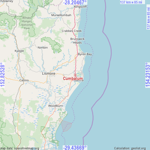
Cumbalum GPS coordinates[2]
28° 49' 21" South, 153° 31' 42.24" East
| Map corner | latitude | longitude |
|---|---|---|
| Upper-left | -28.20467°, | 152.82528° |
| Center: | -28.8225°, | 153.5284° |
| Lower-right: | -29.43669°, | 154.23153° |
| Map W x H: | 137×137 km | = 85.1×85.1mi |
| max Lat: | -10.58257° ⇑26.6% North |
| Cumbalum: | -28.8225° |
| min Lat: | ⇓73.4% South -43.31423° |
| min Long | Cumbalum | max Long |
| 113.53327° | 153.5284° | 153.61246° |
| W 99.5%⇐ | ⇒0.5% E |
Elevation
Elevation of Cumbalum is 3 m = 10 ft, and this is 119 m = 390 ft below average elevation for this country.
| Max E: |
1715 m = 5627 ft | 98.8% |
| Avg. | 122 m = 400 ft | |
| Cumbalum | 3 m = 10 ft | |
Min E: |
-2 m = -7 ft | 1.2% |
See also: Australia elevation on elevation.city.
Geographical zone
Cumbalum is located in South temperate zone (between Tropic of Capricorn and the Antarctic Circle). Distance of this Southern Tropic circle is 598.8 km =372.1 mi to North.| Distance of | km | miles | from Cumbalum |
|---|---|---|---|
| Equator | 3204.8 | 1991.4 | to North |
| Tropic Capricorn | 598.8 | 372.1 | to North |
| Antarctic Circle | 4196.4 | 2607.5 | to South |
| South Pole | 6802.3 | 4226.8 | to South |


Nearby cities:
15 places around Cumbalum: (largest is in red/bold)
• Alstonville
8.9 km =5.5 mi,  255°
255°
• Ballina
5.9 km =3.7 mi,  142°
142°
• Bangalow
15.2 km =9.4 mi,  357°
357°
• Clunes
15.6 km =9.7 mi,  310°
310°
• East Ballina
6.9 km =4.3 mi,  123°
123°
• Ewingsdale
20.8 km =12.9 mi,  6°
6°
• Goonellabah
20.6 km =12.8 mi,  271°
271°
• Lennox Head
7.1 km =4.4 mi,  60°
60°
• McLeans Ridges
14.4 km =8.9 mi,  280°
280°
• Skennars Head
7.2 km =4.5 mi,  95°
95°
• Suffolk Park
16.9 km =10.5 mi,  27°
27°
• Tintenbar
2.7 km =1.7 mi,  346°
346°
• Wardell
15.7 km =9.8 mi,  204°
204°
• West Ballina
4.4 km =2.7 mi,  174°
174°
• Wollongbar
12.8 km =8 mi, 272°
Sources, notices
• [Note1] Compared only with cities in Australia existing in our database
• [Src1] Map data: © OpenStreetMap contributors (CC-BY-SA)
• [Src2] Other city data from geonames.org with taken over terms of usage.
• [Src3] Geographical zone / Annual Mean Temperature by Robert A. Rohde @ Wikipedia
