Tintenbar geodata
Tintenbar (New South Wales) is a populated place; located in Australia in Australia/Sydney (GMT+11) time zone. With population of 797 people, there are 4155 cities with bigger population in this country. Compared to other cities in Australia, 73.6% of cities are located further ↓South; 99.4% of cities are located further ←West and 91.8% of cities have higher elevation than Tintenbar. Note1


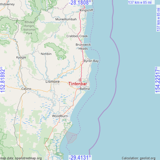
Tintenbar GPS coordinates[2]
28° 47' 55.572" South, 153° 31' 19.344" East
| Map corner | latitude | longitude |
|---|---|---|
| Upper-left | -28.1808°, | 152.81892° |
| Center: | -28.79877°, | 153.52204° |
| Lower-right: | -29.4131°, | 154.22517° |
| Map W x H: | 137×137 km | = 85.1×85.1mi |
| max Lat: | -10.58257° ⇑26.4% North |
| Tintenbar: | -28.79877° |
| min Lat: | ⇓73.6% South -43.31423° |
| min Long | Tintenbar | max Long |
| 113.53327° | 153.52204° | 153.61246° |
| W 99.4%⇐ | ⇒0.59999999999999% E |
Elevation
Elevation of Tintenbar is 8 m = 26 ft, and this is 114 m = 374 ft below average elevation for this country.
| Max E: |
1715 m = 5627 ft | 91.8% |
| Avg. | 122 m = 400 ft | |
| Tintenbar | 8 m = 26 ft | |
Min E: |
-2 m = -7 ft | 8.2% |
See also: Australia elevation on elevation.city.
Geographical zone
Tintenbar is located in South temperate zone (between Tropic of Capricorn and the Antarctic Circle). Distance of this Southern Tropic circle is 596.2 km =370.5 mi to North.| Distance of | km | miles | from Tintenbar |
|---|---|---|---|
| Equator | 3202.1 | 1989.7 | to North |
| Tropic Capricorn | 596.2 | 370.5 | to North |
| Antarctic Circle | 4199.1 | 2609.2 | to South |
| South Pole | 6804.9 | 4228.4 | to South |


Nearby cities:
15 places around Tintenbar: (largest is in red/bold)
• Alstonville
9.3 km =5.8 mi,  238°
238°
• Ballina
8.4 km =5.2 mi,  149°
149°
• Bangalow
12.5 km =7.8 mi,  359°
359°
• Clunes
13.5 km =8.4 mi,  303°
303°
• Cumbalum
2.7 km =1.7 mi,  166°
166°
• East Ballina
9.1 km =5.7 mi,  135°
135°
• Ewingsdale
18.3 km =11.4 mi,  9°
9°
• Federal
18.1 km =11.2 mi,  337°
337°
• Lennox Head
6.9 km =4.3 mi,  83°
83°
• McLeans Ridges
13.5 km =8.4 mi,  269°
269°
• Skennars Head
8.5 km =5.3 mi,  113°
113°
• Suffolk Park
15 km =9.3 mi,  34°
34°
• Wardell
17.9 km =11.1 mi,  199°
199°
• West Ballina
7.1 km =4.4 mi, 171°
• Wollongbar
12.4 km =7.7 mi,  259°
259°
Sources, notices
• [Note1] Compared only with cities in Australia existing in our database
• [Src1] Map data: © OpenStreetMap contributors (CC-BY-SA)
• [Src2] Other city data from geonames.org with taken over terms of usage.
• [Src3] Geographical zone / Annual Mean Temperature by Robert A. Rohde @ Wikipedia
