Alstonville geodata
Alstonville (New South Wales) is a populated place; located in Australia in Australia/Sydney (GMT+11) time zone. With population of 5,662 people, there are 1296 cities with bigger population in this country. Compared to other cities in Australia, 73.3% of cities are located further ↓South; 99.1% of cities are located further ←West and 77.6% of cities have lower elevation than Alstonville. Note1


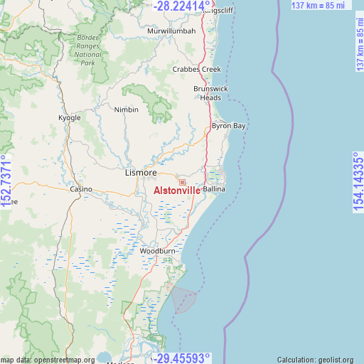
Alstonville GPS coordinates[2]
28° 50' 30.696" South, 153° 26' 24.792" East
| Map corner | latitude | longitude |
|---|---|---|
| Upper-left | -28.22414°, | 152.7371° |
| Center: | -28.84186°, | 153.44022° |
| Lower-right: | -29.45593°, | 154.14335° |
| Map W x H: | 137×137 km | = 85.1×85.1mi |
| max Lat: | -10.58257° ⇑26.7% North |
| Alstonville: | -28.84186° |
| min Lat: | ⇓73.3% South -43.31423° |
| min Long | Alstonville | max Long |
| 113.53327° | 153.44022° | 153.61246° |
| W 99.1%⇐ | ⇒0.90000000000001% E |
Elevation
Elevation of Alstonville is 152 m = 499 ft, and this is 30 m = 98 ft above average elevation for this country.
| Max E: |
1715 m = 5627 ft | 22.4% |
| Alstonville | 152 m 499 ft | |
| Avg. | 122 m = 400 ft | |
Min E: |
-2 m = -7 ft | 77.6% |
See also: Australia elevation on elevation.city.
Geographical zone
Alstonville is located in South temperate zone (between Tropic of Capricorn and the Antarctic Circle). Distance of this Southern Tropic circle is 601 km =373.4 mi to North.| Distance of | km | miles | from Alstonville |
|---|---|---|---|
| Equator | 3206.9 | 1992.7 | to North |
| Tropic Capricorn | 601 | 373.4 | to North |
| Antarctic Circle | 4194.3 | 2606.2 | to South |
| South Pole | 6800.1 | 4225.4 | to South |


Nearby cities:
15 places around Alstonville: (largest is in red/bold)
• Ballina
12.4 km =7.7 mi,  101°
101°
• Clunes
12.7 km =7.9 mi,  345°
345°
• Cumbalum
8.9 km =5.5 mi,  75°
75°
• East Ballina
14.4 km =8.9 mi, 96°
• East Lismore
14.9 km =9.3 mi,  276°
276°
• Girards Hill
16.1 km =10 mi, 279°
• Goonellabah
12.4 km =7.7 mi, 283°
• Lennox Head
15.8 km =9.8 mi,  69°
69°
• Lismore Heights
14.4 km =8.9 mi,  288°
288°
• McLeans Ridges
7.2 km =4.5 mi,  310°
310°
• Skennars Head
15.8 km =9.8 mi, 84°
• Tintenbar
9.3 km =5.8 mi,  58°
58°
• Wardell
12.3 km =7.6 mi,  170°
170°
• West Ballina
9.3 km =5.8 mi, 103°
• Wollongbar
5 km =3.1 mi,  301°
301°
Sources, notices
• [Note1] Compared only with cities in Australia existing in our database
• [Src1] Map data: © OpenStreetMap contributors (CC-BY-SA)
• [Src2] Other city data from geonames.org with taken over terms of usage.
• [Src3] Geographical zone / Annual Mean Temperature by Robert A. Rohde @ Wikipedia
