West Ballina geodata
West Ballina (New South Wales) is a section of populated place; located in Australia in Australia/Sydney (GMT+11) time zone. With population of 3,027 people, there are 2240 cities with bigger population in this country. Compared to other cities in Australia, 73.2% of cities are located further ↓South; 99.5% of cities are located further ←West and 96.8% of cities have higher elevation than West Ballina. Note1


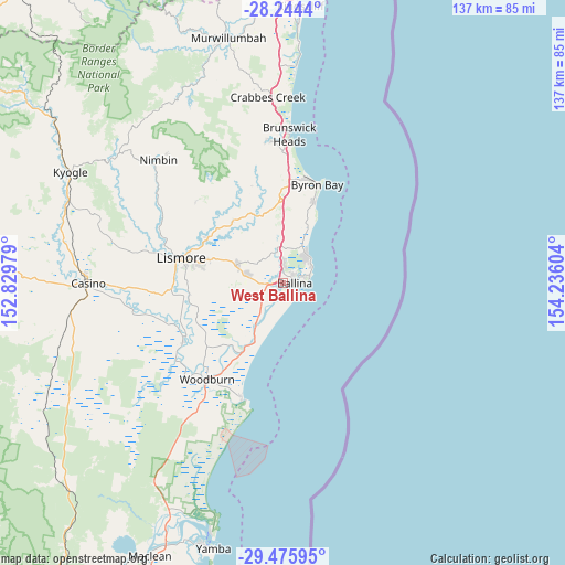
West Ballina GPS coordinates[2]
28° 51' 43.2" South, 153° 31' 58.476" East
| Map corner | latitude | longitude |
|---|---|---|
| Upper-left | -28.2444°, | 152.82979° |
| Center: | -28.862°, | 153.53291° |
| Lower-right: | -29.47595°, | 154.23604° |
| Map W x H: | 136.9×136.9 km | = 85.1×85.1mi |
| max Lat: | -10.58257° ⇑26.8% North |
| West Ballina: | -28.862° |
| min Lat: | ⇓73.2% South -43.31423° |
| min Long | West Ballina | max Long |
| 113.53327° | 153.53291° | 153.61246° |
| W 99.5%⇐ | ⇒0.5% E |
Elevation
Elevation of West Ballina is 5 m = 16 ft, and this is 117 m = 384 ft below average elevation for this country.
| Max E: |
1715 m = 5627 ft | 96.8% |
| Avg. | 122 m = 400 ft | |
| West Ballina | 5 m = 16 ft | |
Min E: |
-2 m = -7 ft | 3.2% |
See also: Australia elevation on elevation.city.
Geographical zone
West Ballina is located in South temperate zone (between Tropic of Capricorn and the Antarctic Circle). Distance of this Southern Tropic circle is 603.2 km =374.8 mi to North.| Distance of | km | miles | from West Ballina |
|---|---|---|---|
| Equator | 3209.2 | 1994.1 | to North |
| Tropic Capricorn | 603.2 | 374.8 | to North |
| Antarctic Circle | 4192 | 2604.8 | to South |
| South Pole | 6797.9 | 4224 | to South |


Nearby cities:
15 places around West Ballina: (largest is in red/bold)
• Alstonville
9.3 km =5.8 mi,  283°
283°
• Ballina
3.2 km =2 mi,  94°
94°
• Bangalow
19.6 km =12.2 mi,  356°
356°
• Broadwater
19.1 km =11.9 mi,  209°
209°
• Clunes
19 km =11.8 mi,  319°
319°
• Cumbalum
4.4 km =2.7 mi,  354°
354°
• East Ballina
5.3 km =3.3 mi,  84°
84°
• Goonellabah
21.7 km =13.5 mi, 283°
• Lennox Head
9.7 km =6 mi,  36°
36°
• McLeans Ridges
16.1 km =10 mi,  295°
295°
• Skennars Head
7.7 km =4.8 mi,  61°
61°
• Suffolk Park
20.7 km =12.9 mi,  21°
21°
• Tintenbar
7.1 km =4.4 mi, 351°
• Wardell
12.1 km =7.5 mi, 214°
• Wollongbar
14.1 km =8.8 mi,  290°
290°
Sources, notices
• [Note1] Compared only with cities in Australia existing in our database
• [Src1] Map data: © OpenStreetMap contributors (CC-BY-SA)
• [Src2] Other city data from geonames.org with taken over terms of usage.
• [Src3] Geographical zone / Annual Mean Temperature by Robert A. Rohde @ Wikipedia
