Wycheproof geodata
Wycheproof (Victoria) is a populated place; located in Australia in Australia/Melbourne (GMT+11) time zone. With population of 624 people, there are 4506 cities with bigger population in this country. Compared to other cities in Australia, 78.7% of cities are located further ↑North; 73.9% of cities are located further →East and 72.2% of cities have lower elevation than Wycheproof. Note1


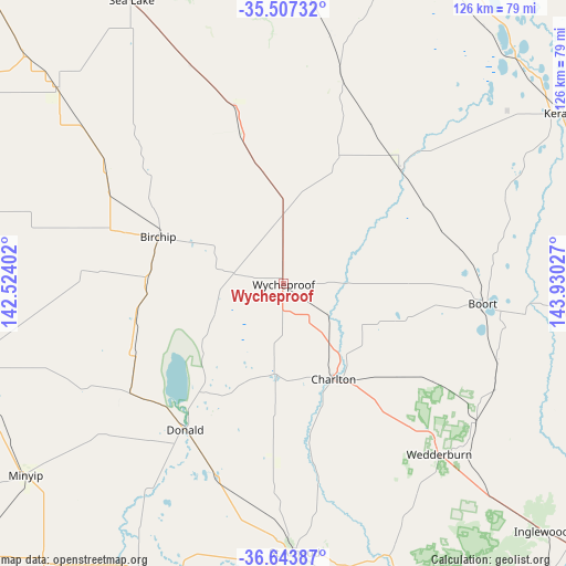
Wycheproof GPS coordinates[2]
36° 4' 39.54" South, 143° 13' 37.704" East
| Map corner | latitude | longitude |
|---|---|---|
| Upper-left | -35.50732°, | 142.52402° |
| Center: | -36.07765°, | 143.22714° |
| Lower-right: | -36.64387°, | 143.93027° |
| Map W x H: | 126.4×126.4 km | = 78.5×78.5mi |
| max Lat: | -10.58257° ⇑78.7% North |
| Wycheproof: | -36.07765° |
| min Lat: | ⇓21.3% South -43.31423° |
| min Long | Wycheproof | max Long |
| 113.53327° | 143.22714° | 153.61246° |
| W 26.1%⇐ | ⇒73.9% E |
Elevation
Elevation of Wycheproof is 113 m = 371 ft, and this is 9 m = 30 ft below average elevation for this country.
| Max E: |
1715 m = 5627 ft | 27.8% |
| Avg. | 122 m = 400 ft | |
| Wycheproof | 113 m = 371 ft | |
Min E: |
-2 m = -7 ft | 72.2% |
See also: Australia elevation on elevation.city.
Geographical zone
Wycheproof is located in South temperate zone (between Tropic of Capricorn and the Antarctic Circle). Distance of this Southern Tropic circle is 1405.5 km =873.3 mi to North.| Distance of | km | miles | from Wycheproof |
|---|---|---|---|
| Equator | 4011.5 | 2492.6 | to North |
| Tropic Capricorn | 1405.5 | 873.3 | to North |
| Antarctic Circle | 3389.7 | 2106.3 | to South |
| South Pole | 5995.6 | 3725.5 | to South |


Nearby cities:
15 places around Wycheproof: (largest is in red/bold)
• Birchip
29.8 km =18.5 mi,  290°
290°
• Boort
44.5 km =27.7 mi,  95°
95°
• Charlton
23.5 km =14.6 mi,  152°
152°
• Donald
39.2 km =24.4 mi,  214°
214°
• Hopetoun
86.8 km =53.9 mi,  296°
296°
• Inglewood
79.7 km =49.5 mi,  133°
133°
• Kerang
73.1 km =45.4 mi,  58°
58°
• Lake Boga
77.5 km =48.2 mi,  28°
28°
• Murtoa
91 km =56.5 mi,  228°
228°
• Pyramid Hill
79.8 km =49.6 mi,  88°
88°
• Rupanyup
81.2 km =50.5 mi,  221°
221°
• Sea Lake
72.3 km =44.9 mi,  331°
331°
• Swan Hill
87.4 km =54.3 mi,  19°
19°
• Warracknabeal
77.4 km =48.1 mi,  255°
255°
• Wedderburn
51.4 km =31.9 mi,  137°
137°
Sources, notices
• [Note1] Compared only with cities in Australia existing in our database
• [Src1] Map data: © OpenStreetMap contributors (CC-BY-SA)
• [Src2] Other city data from geonames.org with taken over terms of usage.
• [Src3] Geographical zone / Annual Mean Temperature by Robert A. Rohde @ Wikipedia
