Boort geodata
Boort (Victoria) is a populated place; located in Australia in Australia/Melbourne (GMT+11) time zone. With population of 836 people, there are 4083 cities with bigger population in this country. Compared to other cities in Australia, 78.8% of cities are located further ↑North; 73.4% of cities are located further →East and 68.4% of cities have lower elevation than Boort. Note1


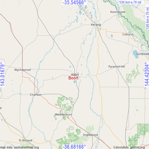
Boort GPS coordinates[2]
36° 6' 56.556" South, 143° 43' 11.676" East
| Map corner | latitude | longitude |
|---|---|---|
| Upper-left | -35.54566°, | 143.01679° |
| Center: | -36.11571°, | 143.71991° |
| Lower-right: | -36.68166°, | 144.42304° |
| Map W x H: | 126.3×126.3 km | = 78.5×78.5mi |
| max Lat: | -10.58257° ⇑78.8% North |
| Boort: | -36.11571° |
| min Lat: | ⇓21.2% South -43.31423° |
| min Long | Boort | max Long |
| 113.53327° | 143.71991° | 153.61246° |
| W 26.6%⇐ | ⇒73.4% E |
Elevation
Elevation of Boort is 94 m = 308 ft, and this is 28 m = 92 ft below average elevation for this country.
| Max E: |
1715 m = 5627 ft | 31.6% |
| Avg. | 122 m = 400 ft | |
| Boort | 94 m = 308 ft | |
Min E: |
-2 m = -7 ft | 68.4% |
See also: Australia elevation on elevation.city.
Geographical zone
Boort is located in South temperate zone (between Tropic of Capricorn and the Antarctic Circle). Distance of this Southern Tropic circle is 1409.8 km =876 mi to North.| Distance of | km | miles | from Boort |
|---|---|---|---|
| Equator | 4015.7 | 2495.2 | to North |
| Tropic Capricorn | 1409.8 | 876 | to North |
| Antarctic Circle | 3385.5 | 2103.7 | to South |
| South Pole | 5991.4 | 3722.9 | to South |


Nearby cities:
15 places around Boort: (largest is in red/bold)
• Barham
65.7 km =40.8 mi,  34°
34°
• Birchip
73.6 km =45.7 mi,  281°
281°
• Charlton
37.2 km =23.1 mi,  243°
243°
• Cohuna
56.5 km =35.1 mi,  52°
52°
• Donald
72 km =44.7 mi,  247°
247°
• Gunbower
61 km =37.9 mi,  73°
73°
• Inglewood
52.8 km =32.8 mi,  165°
165°
• Kerang
46 km =28.6 mi,  23°
23°
• Koondrook
65 km =40.4 mi, 34°
• Lake Boga
73 km =45.4 mi,  353°
353°
• Leitchville
57.4 km =35.7 mi, 65°
• Lockington
75.4 km =46.9 mi,  103°
103°
• Pyramid Hill
36.1 km =22.4 mi,  79°
79°
• Wedderburn
35 km =21.7 mi,  195°
195°
• Wycheproof
44.5 km =27.7 mi, 275°
Sources, notices
• [Note1] Compared only with cities in Australia existing in our database
• [Src1] Map data: © OpenStreetMap contributors (CC-BY-SA)
• [Src2] Other city data from geonames.org with taken over terms of usage.
• [Src3] Geographical zone / Annual Mean Temperature by Robert A. Rohde @ Wikipedia
