Charlton geodata
Charlton (Victoria) is a populated place; located in Australia in Australia/Melbourne (GMT+11) time zone. With population of 1,017 people, there are 3795 cities with bigger population in this country. Compared to other cities in Australia, 79.3% of cities are located further ↑North; 73.8% of cities are located further →East and 75.4% of cities have lower elevation than Charlton. Note1


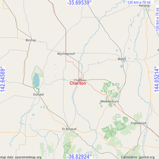
Charlton GPS coordinates[2]
36° 15' 51.732" South, 143° 20' 56.436" East
| Map corner | latitude | longitude |
|---|---|---|
| Upper-left | -35.69539°, | 142.64589° |
| Center: | -36.26437°, | 143.34901° |
| Lower-right: | -36.82924°, | 144.05214° |
| Map W x H: | 126.1×126.1 km | = 78.4×78.4mi |
| max Lat: | -10.58257° ⇑79.3% North |
| Charlton: | -36.26437° |
| min Lat: | ⇓20.7% South -43.31423° |
| min Long | Charlton | max Long |
| 113.53327° | 143.34901° | 153.61246° |
| W 26.2%⇐ | ⇒73.8% E |
Elevation
Elevation of Charlton is 135 m = 443 ft, and this is 13 m = 43 ft above average elevation for this country.
| Max E: |
1715 m = 5627 ft | 24.6% |
| Charlton | 135 m 443 ft | |
| Avg. | 122 m = 400 ft | |
Min E: |
-2 m = -7 ft | 75.4% |
See also: Australia elevation on elevation.city.
Geographical zone
Charlton is located in South temperate zone (between Tropic of Capricorn and the Antarctic Circle). Distance of this Southern Tropic circle is 1426.3 km =886.3 mi to North.| Distance of | km | miles | from Charlton |
|---|---|---|---|
| Equator | 4032.2 | 2505.5 | to North |
| Tropic Capricorn | 1426.3 | 886.3 | to North |
| Antarctic Circle | 3369 | 2093.4 | to South |
| South Pole | 5974.8 | 3712.6 | to South |


Nearby cities:
15 places around Charlton: (largest is in red/bold)
• Avoca
92.5 km =57.5 mi,  173°
173°
• Birchip
49.8 km =30.9 mi,  308°
308°
• Boort
37.2 km =23.1 mi,  63°
63°
• Donald
34.9 km =21.7 mi,  250°
250°
• Dunolly
74.6 km =46.4 mi,  152°
152°
• Inglewood
57.9 km =36 mi,  126°
126°
• Kerang
78.1 km =48.5 mi,  41°
41°
• Lake Boga
92.7 km =57.6 mi,  16°
16°
• Marong
87.4 km =54.3 mi, 126°
• Murtoa
88.3 km =54.9 mi,  243°
243°
• Pyramid Hill
72.5 km =45 mi,  71°
71°
• Rupanyup
75.9 km =47.2 mi, 237°
• Warracknabeal
85.7 km =53.3 mi,  270°
270°
• Wedderburn
29.3 km =18.2 mi, 125°
• Wycheproof
23.5 km =14.6 mi,  332°
332°
Sources, notices
• [Note1] Compared only with cities in Australia existing in our database
• [Src1] Map data: © OpenStreetMap contributors (CC-BY-SA)
• [Src2] Other city data from geonames.org with taken over terms of usage.
• [Src3] Geographical zone / Annual Mean Temperature by Robert A. Rohde @ Wikipedia
