Donald geodata
Donald (Victoria) is a populated place; located in Australia in Australia/Melbourne (GMT+11) time zone. With population of 1,469 people, there are 3307 cities with bigger population in this country. Compared to other cities in Australia, 79.6% of cities are located further ↑North; 74% of cities are located further →East and 72.3% of cities have lower elevation than Donald. Note1


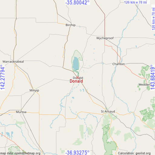
Donald GPS coordinates[2]
36° 22' 7.104" South, 142° 58' 51.816" East
| Map corner | latitude | longitude |
|---|---|---|
| Upper-left | -35.80042°, | 142.27794° |
| Center: | -36.36864°, | 142.98106° |
| Lower-right: | -36.93275°, | 143.68419° |
| Map W x H: | 125.9×125.9 km | = 78.2×78.2mi |
| max Lat: | -10.58257° ⇑79.6% North |
| Donald: | -36.36864° |
| min Lat: | ⇓20.4% South -43.31423° |
| min Long | Donald | max Long |
| 113.53327° | 142.98106° | 153.61246° |
| W 26%⇐ | ⇒74% E |
Elevation
Elevation of Donald is 114 m = 374 ft, and this is 8 m = 26 ft below average elevation for this country.
| Max E: |
1715 m = 5627 ft | 27.7% |
| Avg. | 122 m = 400 ft | |
| Donald | 114 m = 374 ft | |
Min E: |
-2 m = -7 ft | 72.3% |
See also: Australia elevation on elevation.city.
Geographical zone
Donald is located in South temperate zone (between Tropic of Capricorn and the Antarctic Circle). Distance of this Southern Tropic circle is 1437.9 km =893.5 mi to North.| Distance of | km | miles | from Donald |
|---|---|---|---|
| Equator | 4043.8 | 2512.7 | to North |
| Tropic Capricorn | 1437.9 | 893.5 | to North |
| Antarctic Circle | 3357.4 | 2086.2 | to South |
| South Pole | 5963.2 | 3705.4 | to South |


Nearby cities:
15 places around Donald: (largest is in red/bold)
• Birchip
43.2 km =26.8 mi,  352°
352°
• Boort
72 km =44.7 mi,  67°
67°
• Charlton
34.9 km =21.7 mi, 70°
• Dimboola
85.4 km =53.1 mi,  263°
263°
• Dunolly
86.6 km =53.8 mi,  129°
129°
• Haven
82.7 km =51.4 mi,  238°
238°
• Hopetoun
90.2 km =56 mi,  322°
322°
• Horsham
79.5 km =49.4 mi, 241°
• Inglewood
82.6 km =51.3 mi,  106°
106°
• Murtoa
53.8 km =33.4 mi, 238°
• Rupanyup
42.6 km =26.5 mi,  227°
227°
• Stawell
78.5 km =48.8 mi,  193°
193°
• Warracknabeal
54.2 km =33.7 mi,  283°
283°
• Wedderburn
56.9 km =35.4 mi,  95°
95°
• Wycheproof
39.2 km =24.4 mi,  34°
34°
Sources, notices
• [Note1] Compared only with cities in Australia existing in our database
• [Src1] Map data: © OpenStreetMap contributors (CC-BY-SA)
• [Src2] Other city data from geonames.org with taken over terms of usage.
• [Src3] Geographical zone / Annual Mean Temperature by Robert A. Rohde @ Wikipedia
