Uki geodata
Uki (New South Wales) is a section of populated place; located in Australia in Australia/Sydney (GMT+11) time zone. With population of 687 people, there are 4347 cities with bigger population in this country. Compared to other cities in Australia, 74.6% of cities are located further ↓South; 98% of cities are located further ←West and 59.2% of cities have higher elevation than Uki. Note1


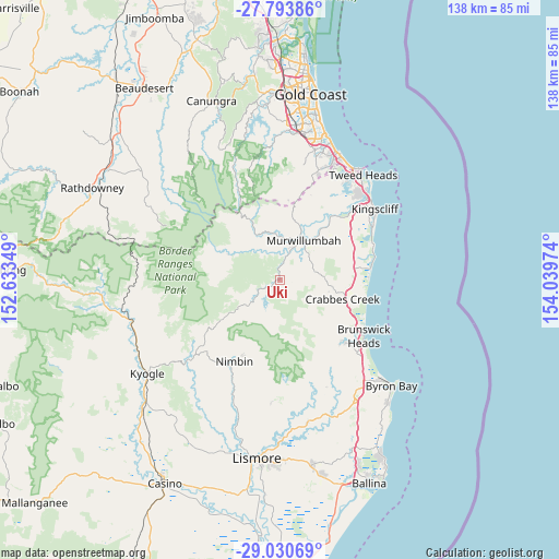
Uki GPS coordinates[2]
28° 24' 50.688" South, 153° 20' 11.796" East
| Map corner | latitude | longitude |
|---|---|---|
| Upper-left | -27.79386°, | 152.63349° |
| Center: | -28.41408°, | 153.33661° |
| Lower-right: | -29.03069°, | 154.03974° |
| Map W x H: | 137.5×137.5 km | = 85.4×85.4mi |
| max Lat: | -10.58257° ⇑25.4% North |
| Uki: | -28.41408° |
| min Lat: | ⇓74.6% South -43.31423° |
| min Long | Uki | max Long |
| 113.53327° | 153.33661° | 153.61246° |
| W 98%⇐ | ⇒2% E |
Elevation
Elevation of Uki is 33 m = 108 ft, and this is 89 m = 292 ft below average elevation for this country.
| Max E: |
1715 m = 5627 ft | 59.2% |
| Avg. | 122 m = 400 ft | |
| Uki | 33 m = 108 ft | |
Min E: |
-2 m = -7 ft | 40.8% |
See also: Australia elevation on elevation.city.
Geographical zone
Uki is located in South temperate zone (between Tropic of Capricorn and the Antarctic Circle). Distance of this Southern Tropic circle is 553.4 km =343.9 mi to North.| Distance of | km | miles | from Uki |
|---|---|---|---|
| Equator | 3159.3 | 1963.1 | to North |
| Tropic Capricorn | 553.4 | 343.9 | to North |
| Antarctic Circle | 4241.8 | 2635.7 | to South |
| South Pole | 6847.7 | 4255 | to South |


Nearby cities:
15 places around Uki: (largest is in red/bold)
• Bray Park
9 km =5.6 mi,  25°
25°
• Burringbar
13.6 km =8.5 mi,  100°
100°
• Currumbin Valley
23.6 km =14.7 mi,  13°
13°
• Mullumbimby
22.1 km =13.7 mi,  133°
133°
• Mullumbimby Creek
17.7 km =11 mi,  146°
146°
• Murwillumbah
11.1 km =6.9 mi, 29°
• Nimbin
23 km =14.3 mi,  208°
208°
• Nunderi
15.8 km =9.8 mi,  49°
49°
• Ocean Shores
22.3 km =13.9 mi,  118°
118°
• Pottsville
21.9 km =13.6 mi,  82°
82°
• Pottsville Beach
22.6 km =14 mi, 82°
• South Golden Beach
22.6 km =14 mi,  114°
114°
• South Murwillumbah
10.4 km =6.5 mi,  36°
36°
• Stokers Siding
7.6 km =4.7 mi,  85°
85°
• Tyalgum
14.3 km =8.9 mi,  296°
296°
Sources, notices
• [Note1] Compared only with cities in Australia existing in our database
• [Src1] Map data: © OpenStreetMap contributors (CC-BY-SA)
• [Src2] Other city data from geonames.org with taken over terms of usage.
• [Src3] Geographical zone / Annual Mean Temperature by Robert A. Rohde @ Wikipedia
