South Murwillumbah geodata
South Murwillumbah (New South Wales) is a section of populated place; located in Australia in Australia/Sydney (GMT+11) time zone. With population of 1,126 people, there are 3666 cities with bigger population in this country. Compared to other cities in Australia, 74.8% of cities are located further ↓South; 98.7% of cities are located further ←West and 88.3% of cities have higher elevation than South Murwillumbah. Note1


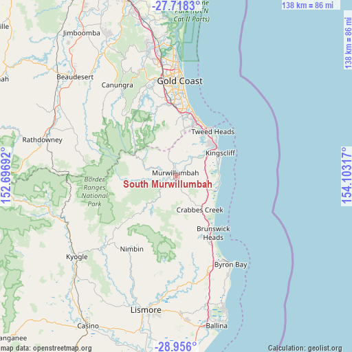
South Murwillumbah GPS coordinates[2]
28° 20' 20.22" South, 153° 24' 0.144" East
| Map corner | latitude | longitude |
|---|---|---|
| Upper-left | -27.7183°, | 152.69692° |
| Center: | -28.33895°, | 153.40004° |
| Lower-right: | -28.956°, | 154.10317° |
| Map W x H: | 137.6×137.6 km | = 85.5×85.5mi |
| max Lat: | -10.58257° ⇑25.2% North |
| South Murwillumbah: | -28.33895° |
| min Lat: | ⇓74.8% South -43.31423° |
| min Long | South Murwillum | max Long |
| 113.53327° | 153.40004° | 153.61246° |
| W 98.7%⇐ | ⇒1.3% E |
Elevation
Elevation of South Murwillumbah is 10 m = 33 ft, and this is 112 m = 367 ft below average elevation for this country.
| Max E: |
1715 m = 5627 ft | 88.3% |
| Avg. | 122 m = 400 ft | |
| South Murwillumbah | 10 m = 33 ft | |
Min E: |
-2 m = -7 ft | 11.7% |
See also: Australia elevation on elevation.city.
Geographical zone
South Murwillumbah is located in South temperate zone (between Tropic of Capricorn and the Antarctic Circle). Distance of this Southern Tropic circle is 545.1 km =338.7 mi to North.| Distance of | km | miles | from South Murwillumbah |
|---|---|---|---|
| Equator | 3151 | 1957.9 | to North |
| Tropic Capricorn | 545.1 | 338.7 | to North |
| Antarctic Circle | 4250.2 | 2641 | to South |
| South Pole | 6856.1 | 4260.2 | to South |


Nearby cities:
15 places around South Murwillumbah: (largest is in red/bold)
• Bilambil Heights
16 km =9.9 mi,  31°
31°
• Bogangar
16.5 km =10.3 mi,  86°
86°
• Bray Park
2.4 km =1.5 mi,  263°
263°
• Burringbar
12.9 km =8 mi,  146°
146°
• Chinderah
16.4 km =10.2 mi,  55°
55°
• Cudgen
16.7 km =10.4 mi, 61°
• Currumbin Valley
14.6 km =9.1 mi,  357°
357°
• Murwillumbah
1.4 km =0.9 mi,  333°
333°
• Nunderi
6.1 km =3.8 mi,  72°
72°
• Pottsville
16.4 km =10.2 mi,  109°
109°
• Pottsville Beach
17.1 km =10.6 mi, 108°
• Stokers Siding
7.9 km =4.9 mi,  169°
169°
• Tallebudgera Valley
16.9 km =10.5 mi,  344°
344°
• Terranora
14.9 km =9.3 mi,  41°
41°
• Uki
10.4 km =6.5 mi,  216°
216°
Sources, notices
• [Note1] Compared only with cities in Australia existing in our database
• [Src1] Map data: © OpenStreetMap contributors (CC-BY-SA)
• [Src2] Other city data from geonames.org with taken over terms of usage.
• [Src3] Geographical zone / Annual Mean Temperature by Robert A. Rohde @ Wikipedia
