Mullumbimby geodata
Mullumbimby (New South Wales) is a populated place; located in Australia in Australia/Sydney (GMT+11) time zone. With population of 3,629 people, there are 1942 cities with bigger population in this country. Compared to other cities in Australia, 74.5% of cities are located further ↓South; 99.3% of cities are located further ←West and 93.8% of cities have higher elevation than Mullumbimby. Note1


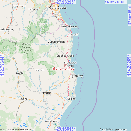
Mullumbimby GPS coordinates[2]
28° 33' 8.496" South, 153° 29' 58.416" East
| Map corner | latitude | longitude |
|---|---|---|
| Upper-left | -27.93295°, | 152.79644° |
| Center: | -28.55236°, | 153.49956° |
| Lower-right: | -29.16815°, | 154.20269° |
| Map W x H: | 137.3×137.3 km | = 85.3×85.3mi |
| max Lat: | -10.58257° ⇑25.5% North |
| Mullumbimby: | -28.55236° |
| min Lat: | ⇓74.5% South -43.31423° |
| min Long | Mullumbimby | max Long |
| 113.53327° | 153.49956° | 153.61246° |
| W 99.3%⇐ | ⇒0.7% E |
Elevation
Elevation of Mullumbimby is 7 m = 23 ft, and this is 115 m = 377 ft below average elevation for this country.
| Max E: |
1715 m = 5627 ft | 93.8% |
| Avg. | 122 m = 400 ft | |
| Mullumbimby | 7 m = 23 ft | |
Min E: |
-2 m = -7 ft | 6.2% |
See also: Australia elevation on elevation.city.
Geographical zone
Mullumbimby is located in South temperate zone (between Tropic of Capricorn and the Antarctic Circle). Distance of this Southern Tropic circle is 568.8 km =353.4 mi to North.| Distance of | km | miles | from Mullumbimby |
|---|---|---|---|
| Equator | 3174.7 | 1972.7 | to North |
| Tropic Capricorn | 568.8 | 353.4 | to North |
| Antarctic Circle | 4226.4 | 2626.2 | to South |
| South Pole | 6832.3 | 4245.4 | to South |


Nearby cities:
15 places around Mullumbimby: (largest is in red/bold)
• Bangalow
15.1 km =9.4 mi,  171°
171°
• Brunswick Heads
4.7 km =2.9 mi,  73°
73°
• Burringbar
13.2 km =8.2 mi,  348°
348°
• Byron Bay
15.5 km =9.6 mi,  134°
134°
• Clunes
21.8 km =13.5 mi,  204°
204°
• Ewingsdale
10.7 km =6.6 mi,  150°
150°
• Federal
11.7 km =7.3 mi, 203°
• Mullumbimby Creek
6.3 km =3.9 mi,  275°
275°
• Myocum
4.9 km =3 mi, 172°
• Ocean Shores
6.1 km =3.8 mi,  37°
37°
• Pottsville
19.2 km =11.9 mi,  17°
17°
• Pottsville Beach
19.3 km =12 mi, 19°
• South Golden Beach
7.6 km =4.7 mi, 37°
• Stokers Siding
18 km =11.2 mi,  332°
332°
• Suffolk Park
18.5 km =11.5 mi,  144°
144°
Sources, notices
• [Note1] Compared only with cities in Australia existing in our database
• [Src1] Map data: © OpenStreetMap contributors (CC-BY-SA)
• [Src2] Other city data from geonames.org with taken over terms of usage.
• [Src3] Geographical zone / Annual Mean Temperature by Robert A. Rohde @ Wikipedia
