Tyalgum geodata
Tyalgum (New South Wales) is a section of populated place; located in Australia in Australia/Sydney (GMT+11) time zone. With population of 537 people, there are 4757 cities with bigger population in this country. Compared to other cities in Australia, 74.7% of cities are located further ↓South; 96.9% of cities are located further ←West and 60.7% of cities have lower elevation than Tyalgum. Note1


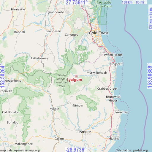
Tyalgum GPS coordinates[2]
28° 21' 23.976" South, 153° 12' 20.736" East
| Map corner | latitude | longitude |
|---|---|---|
| Upper-left | -27.73611°, | 152.50264° |
| Center: | -28.35666°, | 153.20576° |
| Lower-right: | -28.9736°, | 153.90889° |
| Map W x H: | 137.6×137.6 km | = 85.5×85.5mi |
| max Lat: | -10.58257° ⇑25.3% North |
| Tyalgum: | -28.35666° |
| min Lat: | ⇓74.7% South -43.31423° |
| min Long | Tyalgum | max Long |
| 113.53327° | 153.20576° | 153.61246° |
| W 96.9%⇐ | ⇒3.1% E |
Elevation
Elevation of Tyalgum is 66 m = 217 ft, and this is 56 m = 184 ft below average elevation for this country.
| Max E: |
1715 m = 5627 ft | 39.3% |
| Avg. | 122 m = 400 ft | |
| Tyalgum | 66 m = 217 ft | |
Min E: |
-2 m = -7 ft | 60.7% |
See also: Australia elevation on elevation.city.
Geographical zone
Tyalgum is located in South temperate zone (between Tropic of Capricorn and the Antarctic Circle). Distance of this Southern Tropic circle is 547 km =339.9 mi to North.| Distance of | km | miles | from Tyalgum |
|---|---|---|---|
| Equator | 3153 | 1959.2 | to North |
| Tropic Capricorn | 547 | 339.9 | to North |
| Antarctic Circle | 4248.2 | 2639.7 | to South |
| South Pole | 6854.1 | 4258.9 | to South |


Nearby cities:
15 places around Tyalgum: (largest is in red/bold)
• Beechmont
26.2 km =16.3 mi,  357°
357°
• Bilambil Heights
31.4 km =19.5 mi,  60°
60°
• Bonogin
28.1 km =17.5 mi,  30°
30°
• Bray Park
16.8 km =10.4 mi,  84°
84°
• Burringbar
27.6 km =17.1 mi,  108°
108°
• Currumbin Valley
24.8 km =15.4 mi,  48°
48°
• Mullumbimby Creek
30.9 km =19.2 mi,  133°
133°
• Murwillumbah
18.6 km =11.6 mi, 79°
• Nimbin
26.6 km =16.5 mi,  176°
176°
• Nunderi
25.1 km =15.6 mi, 81°
• South Murwillumbah
19.1 km =11.9 mi, 84°
• Springbrook
19.2 km =11.9 mi,  16°
16°
• Stokers Siding
21.2 km =13.2 mi, 105°
• Tallebudgera Valley
23.4 km =14.5 mi,  38°
38°
• Uki
14.3 km =8.9 mi,  116°
116°
Sources, notices
• [Note1] Compared only with cities in Australia existing in our database
• [Src1] Map data: © OpenStreetMap contributors (CC-BY-SA)
• [Src2] Other city data from geonames.org with taken over terms of usage.
• [Src3] Geographical zone / Annual Mean Temperature by Robert A. Rohde @ Wikipedia
