Mullumbimby Creek geodata
Mullumbimby Creek (New South Wales) is a populated locality; located in Australia in Australia/Sydney (GMT+11) time zone. With population of 530 people, there are 4780 cities with bigger population in this country. Compared to other cities in Australia, 74.5% of cities are located further ↓South; 99% of cities are located further ←West and 77.1% of cities have lower elevation than Mullumbimby Creek. Note1


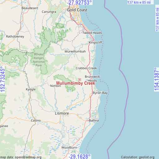
Mullumbimby Creek GPS coordinates[2]
28° 32' 49.128" South, 153° 26' 8.052" East
| Map corner | latitude | longitude |
|---|---|---|
| Upper-left | -27.92753°, | 152.73245° |
| Center: | -28.54698°, | 153.43557° |
| Lower-right: | -29.1628°, | 154.1387° |
| Map W x H: | 137.3×137.4 km | = 85.3×85.4mi |
| max Lat: | -10.58257° ⇑25.5% North |
| Mullumbimby Creek: | -28.54698° |
| min Lat: | ⇓74.5% South -43.31423° |
| min Long | Mullumbimby Cre | max Long |
| 113.53327° | 153.43557° | 153.61246° |
| W 99%⇐ | ⇒1% E |
Elevation
Elevation of Mullumbimby Creek is 149 m = 489 ft, and this is 27 m = 89 ft above average elevation for this country.
| Max E: |
1715 m = 5627 ft | 22.9% |
| Mullumbimby Creek | 149 m 489 ft | |
| Avg. | 122 m = 400 ft | |
Min E: |
-2 m = -7 ft | 77.1% |
See also: Australia elevation on elevation.city.
Geographical zone
Mullumbimby Creek is located in South temperate zone (between Tropic of Capricorn and the Antarctic Circle). Distance of this Southern Tropic circle is 568.2 km =353.1 mi to North.| Distance of | km | miles | from Mullumbimby Creek |
|---|---|---|---|
| Equator | 3174.1 | 1972.3 | to North |
| Tropic Capricorn | 568.2 | 353.1 | to North |
| Antarctic Circle | 4227 | 2626.5 | to South |
| South Pole | 6832.9 | 4245.8 | to South |


Nearby cities:
15 places around Mullumbimby Creek: (largest is in red/bold)
• Bangalow
17.6 km =10.9 mi,  151°
151°
• Brunswick Heads
10.8 km =6.7 mi,  85°
85°
• Burringbar
12.9 km =8 mi,  16°
16°
• Byron Bay
20.7 km =12.9 mi,  123°
123°
• Clunes
20.7 km =12.9 mi,  187°
187°
• Dunoon
19.1 km =11.9 mi,  216°
216°
• Ewingsdale
15.2 km =9.4 mi,  130°
130°
• Federal
11.4 km =7.1 mi,  172°
172°
• Mullumbimby
6.3 km =3.9 mi,  95°
95°
• Myocum
8.8 km =5.5 mi, 128°
• Ocean Shores
10.8 km =6.7 mi,  67°
67°
• Pottsville
21.4 km =13.3 mi,  34°
34°
• South Golden Beach
12.2 km =7.6 mi,  63°
63°
• Stokers Siding
15.5 km =9.6 mi,  352°
352°
• Uki
17.7 km =11 mi,  326°
326°
Sources, notices
• [Note1] Compared only with cities in Australia existing in our database
• [Src1] Map data: © OpenStreetMap contributors (CC-BY-SA)
• [Src2] Other city data from geonames.org with taken over terms of usage.
• [Src3] Geographical zone / Annual Mean Temperature by Robert A. Rohde @ Wikipedia
