Beechmont geodata
Beechmont (Queensland) is a populated place; located in Australia in Australia/Brisbane (GMT+10) time zone. With population of 828 people, there are 4101 cities with bigger population in this country. Compared to other cities in Australia, 75.4% of cities are located further ↓South; 96.5% of cities are located further ←West and 93.6% of cities have lower elevation than Beechmont. Note1


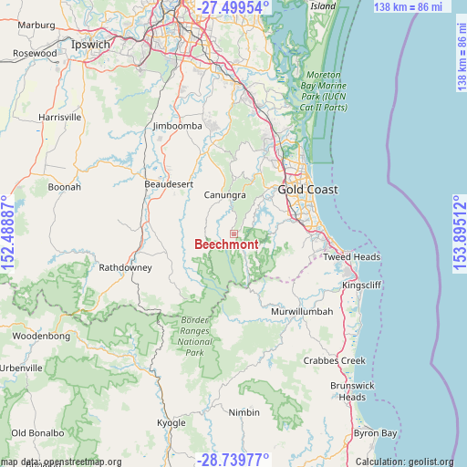
Beechmont GPS coordinates[2]
28° 7' 17.22" South, 153° 11' 31.164" East
| Map corner | latitude | longitude |
|---|---|---|
| Upper-left | -27.49954°, | 152.48887° |
| Center: | -28.12145°, | 153.19199° |
| Lower-right: | -28.73977°, | 153.89512° |
| Map W x H: | 137.9×137.9 km | = 85.7×85.7mi |
| max Lat: | -10.58257° ⇑24.6% North |
| Beechmont: | -28.12145° |
| min Lat: | ⇓75.4% South -43.31423° |
| min Long | Beechmont | max Long |
| 113.53327° | 153.19199° | 153.61246° |
| W 96.5%⇐ | ⇒3.5% E |
Elevation
Elevation of Beechmont is 513 m = 1683 ft, and this is 391 m = 1283 ft above average elevation for this country.
| Max E: |
1715 m = 5627 ft | 6.4% |
| Beechmont | 513 m 1683 ft | |
| Avg. | 122 m = 400 ft | |
Min E: |
-2 m = -7 ft | 93.6% |
See also: Australia elevation on elevation.city.
Geographical zone
Beechmont is located in South temperate zone (between Tropic of Capricorn and the Antarctic Circle). Distance of this Southern Tropic circle is 520.9 km =323.7 mi to North.| Distance of | km | miles | from Beechmont |
|---|---|---|---|
| Equator | 3126.8 | 1942.9 | to North |
| Tropic Capricorn | 520.9 | 323.7 | to North |
| Antarctic Circle | 4274.4 | 2656 | to South |
| South Pole | 6880.2 | 4275.2 | to South |


Nearby cities:
15 places around Beechmont: (largest is in red/bold)
• Advancetown
9.5 km =5.9 mi,  50°
50°
• Bonogin
15.9 km =9.9 mi,  97°
97°
• Canungra
11.9 km =7.4 mi,  347°
347°
• Clagiraba
15 km =9.3 mi,  19°
19°
• Gilston
14.4 km =8.9 mi, 47°
• Highland Park
18.3 km =11.4 mi, 49°
• Lower Beechmont
9.8 km =6.1 mi,  32°
32°
• Mount Nathan
19.2 km =11.9 mi, 24°
• Mudgeeraba
17.6 km =10.9 mi,  76°
76°
• Springbrook
10.5 km =6.5 mi,  138°
138°
• Tallai
14.6 km =9.1 mi,  64°
64°
• Tallebudgera Valley
17.8 km =11.1 mi,  116°
116°
• Tamborine Mountain
16.9 km =10.5 mi,  2°
2°
• Witheren
9.2 km =5.7 mi,  359°
359°
• Worongary
17.4 km =10.8 mi, 62°
Sources, notices
• [Note1] Compared only with cities in Australia existing in our database
• [Src1] Map data: © OpenStreetMap contributors (CC-BY-SA)
• [Src2] Other city data from geonames.org with taken over terms of usage.
• [Src3] Geographical zone / Annual Mean Temperature by Robert A. Rohde @ Wikipedia
