Swansea geodata
Swansea (Tasmania) is a populated place; located in Australia in Australia/Hobart (GMT+11) time zone. With population of 859 people, there are 4047 cities with bigger population in this country. Compared to other cities in Australia, 98.1% of cities are located further ↑North; 51.1% of cities are located further ←West and 85% of cities have higher elevation than Swansea. Note1


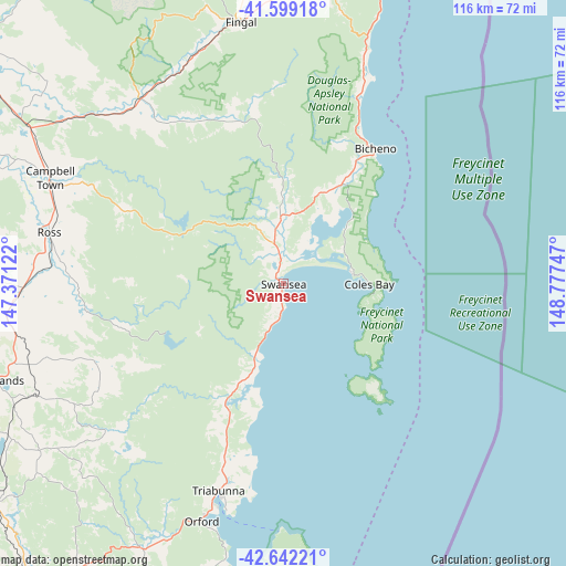
Swansea GPS coordinates[2]
42° 7' 22.224" South, 148° 4' 27.624" East
| Map corner | latitude | longitude |
|---|---|---|
| Upper-left | -41.59918°, | 147.37122° |
| Center: | -42.12284°, | 148.07434° |
| Lower-right: | -42.64221°, | 148.77747° |
| Map W x H: | 116×116 km | = 72.1×72.1mi |
| max Lat: | -10.58257° ⇑98.1% North |
| Swansea: | -42.12284° |
| min Lat: | ⇓1.9% South -43.31423° |
| min Long | Swansea | max Long |
| 113.53327° | 148.07434° | 153.61246° |
| W 51.1%⇐ | ⇒48.9% E |
Elevation
Elevation of Swansea is 12 m = 39 ft, and this is 110 m = 361 ft below average elevation for this country.
| Max E: |
1715 m = 5627 ft | 85% |
| Avg. | 122 m = 400 ft | |
| Swansea | 12 m = 39 ft | |
Min E: |
-2 m = -7 ft | 15% |
See also: Australia elevation on elevation.city.
Geographical zone
Swansea is located in South temperate zone (between Tropic of Capricorn and the Antarctic Circle). Distance of this Southern Tropic circle is 2077.7 km =1291 mi to North.| Distance of | km | miles | from Swansea |
|---|---|---|---|
| Equator | 4683.6 | 2910.3 | to North |
| Tropic Capricorn | 2077.7 | 1291 | to North |
| Antarctic Circle | 2717.6 | 1688.6 | to South |
| South Pole | 5323.4 | 3307.8 | to South |


Nearby cities:
15 places around Swansea: (largest is in red/bold)
• Bicheno
33.4 km =20.8 mi,  34°
34°
• Campania
80.6 km =50.1 mi,  221°
221°
• Campbell Town
52.7 km =32.7 mi,  294°
294°
• Carlton
89.1 km =55.4 mi,  202°
202°
• Dodges Ferry
89.3 km =55.5 mi, 204°
• Forcett
83.5 km =51.9 mi,  205°
205°
• Lewisham
87.5 km =54.4 mi, 205°
• Midway Point
87.1 km =54.1 mi, 210°
• Oatlands
61.6 km =38.3 mi,  251°
251°
• Orford
51.4 km =31.9 mi, 198°
• Richmond
85.8 km =53.3 mi, 217°
• Saint Marys
60.7 km =37.7 mi,  8°
8°
• Scamander
75.7 km =47 mi, 11°
• Sorell
84.4 km =52.4 mi, 209°
• Triabunna
44.9 km =27.9 mi, 197°
Sources, notices
• [Note1] Compared only with cities in Australia existing in our database
• [Src1] Map data: © OpenStreetMap contributors (CC-BY-SA)
• [Src2] Other city data from geonames.org with taken over terms of usage.
• [Src3] Geographical zone / Annual Mean Temperature by Robert A. Rohde @ Wikipedia
