Finley geodata
Finley (New South Wales) is a populated place; located in Australia in Australia/Sydney (GMT+11) time zone. With population of 2,473 people, there are 2592 cities with bigger population in this country. Compared to other cities in Australia, 77.5% of cities are located further ↑North; 59.2% of cities are located further →East and 71.1% of cities have lower elevation than Finley. Note1


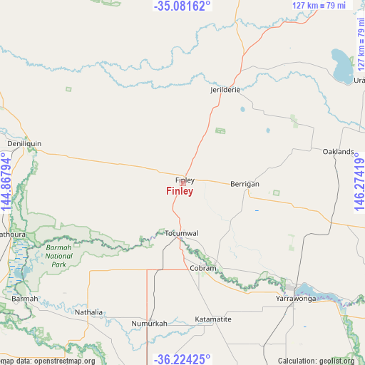
Finley GPS coordinates[2]
35° 39' 17.928" South, 145° 34' 15.816" East
| Map corner | latitude | longitude |
|---|---|---|
| Upper-left | -35.08162°, | 144.86794° |
| Center: | -35.65498°, | 145.57106° |
| Lower-right: | -36.22425°, | 146.27419° |
| Map W x H: | 127×127 km | = 78.9×78.9mi |
| max Lat: | -10.58257° ⇑77.5% North |
| Finley: | -35.65498° |
| min Lat: | ⇓22.5% South -43.31423° |
| min Long | Finley | max Long |
| 113.53327° | 145.57106° | 153.61246° |
| W 40.8%⇐ | ⇒59.2% E |
Elevation
Elevation of Finley is 109 m = 358 ft, and this is 13 m = 43 ft below average elevation for this country.
| Max E: |
1715 m = 5627 ft | 28.9% |
| Avg. | 122 m = 400 ft | |
| Finley | 109 m = 358 ft | |
Min E: |
-2 m = -7 ft | 71.1% |
See also: Australia elevation on elevation.city.
Geographical zone
Finley is located in South temperate zone (between Tropic of Capricorn and the Antarctic Circle). Distance of this Southern Tropic circle is 1358.5 km =844.1 mi to North.| Distance of | km | miles | from Finley |
|---|---|---|---|
| Equator | 3964.5 | 2463.4 | to North |
| Tropic Capricorn | 1358.5 | 844.1 | to North |
| Antarctic Circle | 3436.7 | 2135.5 | to South |
| South Pole | 6042.6 | 3754.7 | to South |


Nearby cities:
15 places around Finley: (largest is in red/bold)
• Barooga
30.1 km =18.7 mi,  158°
158°
• Berrigan
21.7 km =13.5 mi,  91°
91°
• Cobram
30.2 km =18.8 mi,  168°
168°
• Deniliquin
57.5 km =35.7 mi,  283°
283°
• Invergordon
56.9 km =35.4 mi,  178°
178°
• Jerilderie
36 km =22.4 mi,  23°
23°
• Katunga
40.9 km =25.4 mi,  192°
192°
• Mathoura
63 km =39.1 mi,  253°
253°
• Mulwala
53.7 km =33.4 mi,  133°
133°
• Nathalia
55.7 km =34.6 mi,  216°
216°
• Numurkah
49.6 km =30.8 mi, 193°
• Strathmerton
31.2 km =19.4 mi,  195°
195°
• Tocumwal
17.4 km =10.8 mi, 180°
• Yarrawonga
56 km =34.8 mi,  136°
136°
• Yarroweyah
29.9 km =18.6 mi, 182°
Sources, notices
• [Note1] Compared only with cities in Australia existing in our database
• [Src1] Map data: © OpenStreetMap contributors (CC-BY-SA)
• [Src2] Other city data from geonames.org with taken over terms of usage.
• [Src3] Geographical zone / Annual Mean Temperature by Robert A. Rohde @ Wikipedia
